
a collection of notes on areas of personal interest
- Introduction
- Arabic / Islamic design
- Arabic / Islamic geometry 01
- Arabic / Islamic geometry 02
- Arabic / Islamic geometry 03
- Arabic / Islamic geometry 04
- Islamic architecture
- Islamic urban design 01
- Islamic urban design 02
- Islamic urban design 03
- Islamic urban design 04
- Islamic urban design 05
- Arabic / Islamic gardens
- Gulf architecture 01
- Gulf architecture 02
- Gulf architecture 03
- Gulf architecture 04
- Gulf architecture 05
- Gulf architecture 06
- Gulf architecture 07
- Gulf architecture 08
- Infrastructure development
- The building industry
- Environmental control
- Perception
- The household on its lot
- A new approach – conceptual
- A new approach – principles
- A new approach – details
- Al Salata al jadida
- Public housing
- Expatriate housing study
- Apartment housing
- Pressures for change
- The State’s administration
- Society 01
- Society 02
- Society 03
- Society 04
- Society 05
- Society 06
- History of the peninsula
- Geography
- Planning 01
- Planning 02
- Population
- Traditional boats
- Boat types
- Old Qatar 01
- Old Qatar 02
- Security
- Protection
- Design brief
- Design elements
- Building regulations
- Glossary
- Glossary addendum
- References
- References addendum
- Links to other sites
Old buildings

Before I continue with notes relating to the traditional architecture in Qatar I should mention the class of building that came between traditional architecture and modern architecture – the latter being taken as those constructed after the nineteen seventies. This architecture was funded with the beginnings of wealth coming into the country and not related to the traditional source of wealth, mainly pearling. It developed showing respect to traditional architecture, using the skills brought into the country from the Indian sub-continent, northern Islamic countries and Persia.

This first building, shown above and to the right, seems important to me as it illustrates a structure which probably is a traditional building that has been altered and upgraded, but kept its essential character. By this I mean that there is an obviously large majlis on the right of the porch or ruwaaq looking out onto the public space outside. It illustrates an urban architecture and evidently contains a tall space or spaces inside with built-in ventilation grilles at a high level to evacuate heat. Its windows are set low and are of a generous scale as is the main door with its wicket gate. The ventilation slot immediately above the windows illustrates a more sophisticated development of traditional windows, though notice that one of the windows has been blocked up in order to install a single, wall-mounted air-conditioning unit.
Note also that the decoration of the ruwaaq is evidence of the introduction of styling apparently from the Indian sub-continent. However, the detail at the junction of the ruwaaq column and beam has a very Qatari character.
There is a flat roof which appears still to be constructed of traditional materials as the mirzam remain to channel water off the roof as quickly as possible in order to prevent water penetration through the roof construction.
I know no more about the building but it is obviously not being lived in by a Qatari family as, if it were, the outside would be spotless and there would be no rubbish piled up. It is likely that it is being either lived in by expatriates, perhaps employed by the original owner, or is being used as a store as the boxes outside suggest.
Traditional construction
The character of buildings was created by the locals responding to the specific problems posed by the climate, need for security and the social and religious requirements of family life. But it is a truism that traditional buildings did their job better than new ones. Traditional buildings were constructed from the materials which were close at hand and, in the main, which were inexpensive. The materials commonly used in Qatar were desert stones – hasa; limestone mortar – juss; limewash – nuwra; earth – turaab which is either comprised of rawdha – a cultivatable soil, or sand – raml and, in mud form is known as teen; and date palm fronds – sa’af. Everything else was imported and had to be used carefully if cost was to be kept down. Timber – khashab, particularly the heavy teak doors – abwab – necessary for security were used and re-used, as were ceiling joists – shandal – and window shutters – dhafaqat or safaqa.

Sadly many of the old rural buildings have fallen into disrepair and can be seen all over Qatar, particularly in the north of the country. Having said that many of them are now being reconstructed to provide urban dwellers with weekend retreats. Structures such as this provide a good starting point from which to create a complex of rooms usually with a swimming pool filled from a well, shading and planting. In these cases it is not unusual for a watchman to live there who will also have the job of rudimentary farming.

This building, at Wakra, illustrates the trabeated construction that was the standard method by which buildings in the peninsula were built. Although there is evidence in the peninsula of buildings with pitched roofs, they were confined to a simple single-cell type of unit because pitched roofing a large number of rooms was difficult for a number of reasons; it is far easier to join rooms with a flat roof. In trabeated construction there are columns and there are beams, the columns are constructed of hasa or faruwsh and juss, the beams from a number of shandal bound with kumbar to provide a degree of strengthening. From this structure a floor or roof would be supported from a number of shandal spanning between the beams on top of which would be a layer of split canes supporting a mat made from woven palms, itself supporting at least two layers of compacted earth. There is more about this construction on this page.
The early towns were characterised by the materials and scale of the residential elements which comprised the majority of the structures, as well as by the street system which is dealt with elsewhere. The only other buildings within towns were those associated with the suq, and those of the mosques – musajid – which were similarly constructed to houses, but different in form, eventually incorporating in Qatar, small domes – qubba. Following wahhabi tradition, mosques were simple, rectangular buildings though, in the Gulf, they normally had small hemispherical topped towers – burj – associated with them, the tower either on a corner of the roof of the mosque, or in a corner of the entrance yard, and usually with a small staircase.

Here, at al Jumail – between Medinat al-Shamal and al Khuwayr in the north of the peninsula – there is a ruined masjid. Even in its present state of repair it can be seen to typify the architecture of this type of building. Its simple construction is very much a characteristic of wahhabi architecture as well as being a reflection of the simple life led by those who lived in this area of the peninsula.

This photo of the reverse side of the qibla wall of a masjid was also taken at al Jubail in the north of the peninsula. Again, you can see from the mihrab the clean and simple style of architecture which characterised wahhabi masaajid. Although there is some decoration to the top of the mihrab in the form of a small dome it is not ostentatious and is in keeping with the simplicity of the construction. It is also interesting to note the large number of mirzam that have been incorporated into the roof construction in order to get rain water off the roof as quickly as possible in order to prevent damage to it from water penetration. Note, too, how this element of function design requirement introduces visual relief to this wall and a degree of articulation to the roof line, both of them welcome under harsh lighting conditions.
First permanent dwellings

Perhaps the first permanent buildings in the peninsula are likely to have been constructed of ’arish or palm fronds. Within the region there are examples of the use of this material to fashion shelter both in relation to temporary shelter associated with the movement of tribes, but also more permanently in areas where the material was found growing in abundance. This was particularly so, for instance, at the Liwa oasis in what is now the United Arab Emirates, where dates were extensively farmed. This photograph was taken in a Doha barasti and shows the framework for a shelter constructed of ’arish stalks bound together with rope to form a stable structure. Whether or not this is similar to any of the first permanent dwellings is not possible to say, but it may be indicative of the structural form these constructions took – though you should be aware that this is different from those immediately used in the hinterland.
However, the first dwellings were relatively simple and served the purpose of providing not only shelter and security but also of establishing a right to the use of the land which would be visible all year round. In the main the first houses within the interior of Qatar were comparatively small and made from mud bricks with, perhaps, an admixture of straw – libbin, and a pitched roof covered with palm branches, the width of the single room being determined by the span of the roof beams, approximately two metres. Little remains of them now although, until the beginning of the nineteen eighties, it was possible to see the remains of such houses at a number of settlements, particularly at Na’ijah, a little way south of Doha. More permanent houses were soon constructed from desert stones and mud or juss mortar with palm branches for the pitched roofs. The construction of these houses was termed ’arish, though this is usually understood to be the name of the date palms only. The patterns left by some of these developments can still be seen in the desert and some work has been carried out to determine the extent and character of the constructions.
With time these loose developments became more established, reflecting both the proprietorial rights to the area as well as the continuing need to provide a more substantial body of permanent shelters in which the society could develop comfortably throughout the whole of the year – the tents being essentially used only part of the year when the badu traditionally wintered their flocks in the peninsula.
The importance of wells
At the head of the next section there is a photograph that includes the head of a typical desert bi’r. One particularly important consideration, in fact the reason for a settlement being located where it was, would be the availability of a suitable water source for the family and their animals. The bi’r was a hand dug well, its sides reinforced with stones, and would have a channel leading from it into which water could be poured from the well, and from which their animals would drink.

The two photographs here are of two other wells in the heartland of the north of the peninsula. The upper photograph shows the circular well to the right, a short linking channel and a squared trough from which animals would have drunk. It can be seen that the original construction of the bi’r was of desert hasa held in a juss mortar, the top of the bi’r being given a later protection of cement mortar, a more durable material than juss. Note how both it and the two others above and below were all located outside the settlement enclosures.

The second bi’r appears to have been a more modern construction in that it is accurately squared off and finished with cement mortar, though still of desert hasa construction. The linking channel and drinking trough are still present though the relatively small size of the latter implies that few animals will be able to drink at it at the same time. Curiously there appears also to be a steel pipe leading from the bi’r, suggesting the need for an overflow, although I don’t know why that would have been necessary.
Single room

This first image was taken from the air when arriving at one of the Emirates’ airports, probably Sharjah, in the early 1970s. It shows a number of abandoned dwellings, most of them having been constructed with stone walls and having pitched roofs, since removed or fallen. At this distance in time it is impossible to know how the buildings were oriented, but it is significant that most are aligned roughly in parallel with each other, suggesting that there was a common understanding of the weather, particularly the shamaal, and its effects on buildings and, therefore, those living in the buildings. If their backs are oriented towards the shamaal it would suggest that this aerial view of them is from approximately the north-east.

These houses initially contained a single internal space and generally, had a single opening which formed the entrance door and was the source of ventilation and light in the centre of one of the long walls of the building. Here, in a Qatar desert settlement are the ruins of a number of small buildings, one of them designed for a pitched roof which would have been covered with palm fronds – ’arish. These structures have all now gone.
The majority of activities of the family would have continued outside the house as was the custom with activities in tented encampments, though it is probable that the first use of such buildings would have been by a single individual rather than a whole family, as the right to use the land was established. The houses were loosely grouped some distance away from each other, their main characteristics, which they shared with tents, being to turn their backs to the prevailing north north-north-west wind – the shamal – and to have a bi’r in the immediate vicinity.

This photo was taken at al-Bida where a number of traditional buildings have been constructed. You can see from the photo that the structure is not accurate in at least two respects. Firstly, the barasti covering has, below it, some form of modern material to provide weather-proofing. Secondly, the door is a relatively modern one and appears out of character. I’m also dubious about the window. In old buildings of this sort that I have seen the windows are much smaller openings, usually higher up the wall. Compare the roof on this structure with that three photographs lower.
With time the single room became divided into two or more spaces, usually by the incorporation of a low dividing wall at right angles to the long wall. This permitted some privacy as well as maintaining optimal air circulation. A simple window would have been added if the size of the structure permitted it, giving light to the interior, and protected by vertical wrought iron bars on the outside and wooden shutters on the inside. This, together with the heavy door to the house, afforded some protection to the occupants, but not a great deal. The floor level would be raised from that of the surrounding land to prevent flooding of the interior and a verandah was commonly formed to provide a raised living area for the family – an extension to the internal spaces – and a low seat.


While the single rooms were developed over time to become more complex buildings both internally and externally, as illustrated below, some remained as free-standing rooms within more complex developments as is illustrated in these two photographs, both taken in abandoned settlements in the north of the country.
The first shows a grouping at al-Arish in the north of the peninsula. Note that while the walls of the building on the right that had a sloped roof is constructed from hajaraat and juss in the traditional construction style, that on the left was built with concrete blocks, suggesting it was built around thirty of forty years ago, and that it was found easier to construct with a pitched roof than with the more common flat roof.
The second photograph, taken at al-Mufjar in the 1980s, shows a building which had been rehabilitated and supplied with a temporary roofing of ’arish date palm fronds. Note the contrast of the pitched structure with the squared structure with its low window to the left.

With the exception of many of the defensive structures, most of the residential buildings have been constructed with vertical masonry walls. In the case of defensive structures there is a good reason for strengthening the lower parts of walls against attack but, for one and two storey residential structures there is generally no need to do so which is what makes this example unusual. Photographed from the air in October 1972, and lying almost directly underneath the airport’s runway, this structure stands apart from the newer residential buildings to its south and is likely to have been a majlis for the use and enjoyment of those who lived in feriq al-khalifat, and who generally made their living from the adjacent sea. The structure to its east is likely to have been a baraha, an area for sitting in the open. Its positioning suggests that the sea came very close to these two structures before fill was placed here to a distance of around a hundred metres. Note that the structure has five maraazim to shed rainwater swiftly.

Elsewhere in the country the occasional structure with battered walls could be seen in the 1970s. Here, at al-Ghariyah in the north of the country are two rooms which sit alongside others with the more common vertical walls. While the external walls were battered, the internal walls were constructed in a vertical plane, though I have no knowledge of why the walls were battered in the first place unless it was an attempt to keep the structure light. What does appear to notable is that the walls were certainly thicker at their base than the walls of nearby rooms constructed with both faces vertical, perhaps an indication of their builders wanting to provide more strength. Whether this was to do with their sea-side location or a defensive or thermal strategy, I don’t know.
Materials
Hadid, wrought iron and khashab, wood were extremely valuable to the family as the rest of the structure would be constructed from naturally sourced materials found on or around the site. These items would have had a life extending beyond that of the basic enclosed structure and would have be reused as and when necessary. This is particularly true of the roof joists, commonly of mangrove poles and which were not cut to length unless they were used with a degree of ostentation, when they would be trimmed to project the same amount from the face of the building.
The roof was flat and constructed of layers of tamped earth on rush matting held on timber joists. The roof had sufficient falls on it to enable water to be shed quickly. Initially the water was led to the centre of the long side and a vertical channel down the face of the building was used to lead the water quickly away from the house. With time and wealth a timber water spout – mirzam – was incorporated into the roof of the house with the same effect, though designed for the water to fall away from the face of the wall and its footings.
Shade
Shade was given to the front of the house by the relatively simple expedient of covering the mangrove poles which commonly projected from the front of the building. The covering would have been initially a woven mat or, as development progressed, juss would have been laid on top of the mat to form a relatively waterproof finish. Both the roof and the verandah covering were laid to move water off the building rapidly and thus reduce the possibility of water ingress. Of course such roofs need constant maintenance but the materials were readily available and it was a relatively simple job to effect. In the less well finished buildings – in effect, in most buildings in the desert – the mangrove poles projected for different lengths, there being a reluctance to trim such a valuable commodity just for aesthetic reasons.
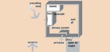
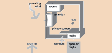
Verandah
With the passing of time, this shading device was extended and developed into a more formal architectural treatment by the construction of a colonnade of columns – awamid. The columns are relatively wide as they were constructed with desert stones and juss as were the walls of the house. This simple, trabeated form had the additional value of providing more shade to the raised verandah by virtue of the shade from the heavy columns, and created a setting for the family to carry out much of their life in relative comfort.

It should be borne in mind that many of the activities of the household were carried out in the open or shade rather than inside the house by preference as enclosure can be psychologically uncomfortable – as well as there being more space outside. It is also notable, and something that seems often to have been forgotten in modern designs, that the verandahs were, and need to be, of a usable width.

Here is a larger building than that above, this time at Sumaismah, south of al Khor. It would have been constructed later than the previous example as can be seen by the use of blockwork and of squared timbers for the lintols. Conceptually it is exactly the same as the smaller building above. Note how there is some deterioration at the foot of the columns due to a combination of rain and mechanical damage.

This appears to be the same building as that in the photograph immediately above, but it illustrates better how this simple work of traditional architecture has been created. The verandah has been taken round at least three sides of the basic room, creating protective shade during the hot summer months as well as shelter from the rain during winter. It is probable that the room is not very old as there appear to be both mangrove poles and sawn timbers used in the roof construction, and the columns are built from concrete blocks. However, it is a direct descendant of the simple traditional room, the only change being the use of slightly more easy to use building materials. The roof appears to be constructed traditionally, though the maraazim have disappeared as witnessed by the two holes on the right edge of the roof, above the columns. Note that the maraazim are located at the side and not at the front. I would have anticipated that they would be at the back where there is the possibility of a shorter run-off for the rainwater.

Here is a photograph of the lower part of a single room development at al-Ruwaidha in the north of the peninsula. It is interesting for the deterioration shown in the base of the column. The main room is constructed of desert stones, hasa, their constructional matrix being juss. The covering of the wall is also likely to be that but has deteriorated at its weakest point, the un-bonded corners, though there is some erosion of the lower part of the wall, probably from rain and driven sand. The columns, however, have been constructed of pre-cast concrete blocks supporting orthogonal beams to provide shelter to the shurfa or verandah. These timbers, being of machined timber rather than the traditional shandal, mangrove poles, indicate that at least the shurfa is relatively new, perhaps around forty years old. Concrete blocks were notoriously badly constructed with regard to mix, salinity of water and curing. It is not surprising that they, together with the layer of rendering have deteriorated in this typical manner, the cause being wind blown sand and dust together with rain over a period of time. Note how the horizontal cement mortar of the columns has deteriorated less than the concrete blocks. This is due to the concrete block mix – aggregate, cement and sand – being poorly mixed and more easily mechanically eroded than mortar which is just sand and cement.
Protection
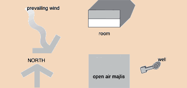
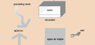
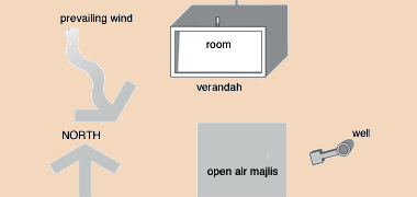
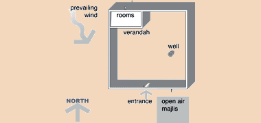
Continuing development of the house established three essential features. Firstly, a protective wall – suwr – was added, commonly continuing the north and west walls of the single building in the north-west of the new compound, and forming the basis for safe family life within a courtyard – sahn. This location was the most suitable as it gave optimum protection to the compound from the prevailing shamal as well as the afternoon sun in summer.

The protective wall not only provided physical security, a degree of privacy as well as protection from the shamal, but it could also contain the family’s animals at night if necessary. In addition, the wall usually contained the families’ well – bi’r, where this existed on their land. While the general purpose of the compound’s boundary wall is to protect those living inside it, there is also a need to be aware of what is happening around it. Normally this would be effected by those outside the wall, but in at least one compound it is interesting to note that provision has been made in the surrounding wall through which to observe what might be happening outside. It is not known why this particular opening was incorporated into the wall, but it is assumed that it was located in such a way as not to compromise privacy within the compound.
The second feature was the establishing of a fixed location immediately outside the south wall for a baraha or hiyala – an open majlis area. This area was protected by the boundary wall from the shamal but was exposed to the sun throughout the day.
Although I have not seen it, an alternative location might have been to the east of the plot where the boundary wall would have protected it in the afternoons against the setting sun. Bear in mind, however, that the area for the majlis was extremely flexible and it is just as likely that a tent might have been pitched here to provide more comfort. Where this was the case, the tent rarely seems to have had its side walls added in the summer months.
Bear in mind that, in summer, the heat build-up in the south- or west-facing walls would have been considerable, and anybody sitting on the baraha would have suffered from the low wave heat radiation given out by the wall, an effect which would have quickly made them feel sick. Hence the probability that the baraha would not have been used in the summer months, and that it is more likely – and my experience – that carpets are put down some way from the wall to be used as the majlis.
With time the baraha was developed into a majlis within the compound, normally occupying the south-east corner with its long axis oriented east-west, as were all major rooms initially.
A particular feature of the baraha was the development of raised seating – dikka (pronounced as ‘ditcher’ in the Gulf) – alongside it. Although Gulf Arabs normally sit on the ground supported on hard cushions – misnad – the seating they developed is relatively high, up to 800mm from the ground. Where wood was at a premium the dikka was constructed as a part of the wall with a small quadrant circular stop at each end providing an elbow rest. Where timber was available it became possible to construct movable seats which were covered in skins, carpets or kilim s.

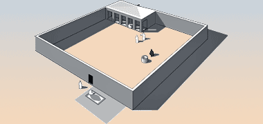
Here, in the desert in the north of the peninsula, lie the ruins of a small structure, complete with the remains of its containing wall. It illustrates perfectly the first stage of a rural development, consisting as it does of a simple building comprised of a couple of room together with a protective wall which would have provided a degree of privacy, the ability to contain animals when necessary, and a small amount of security. There appears not to have been a verandah which suggests that it was a simple building which had not developed this feature, one which would have been of significant benefit and comfort to people living there.

Here, however, there is an obvious veranda developed on the structure to the right of this compound which is a more developed housing plot than that above. In this case, the veranda was established on the building in the near right corner, more buildings being added later moving along the right hand boundary wall. There is also evidence of a structure on the far left back boundary wall and, perhaps, on the left. There is a possibility that this may have been a majlis, but I am not sure of this as there appear to be no openings to the outside on the far wall. However, it is interesting to see that there is also a well on the left surrounded with a small square wall and which would have supplied the inhabitants of the compound with their daily water needs.
With continuing settlement in any specific location and the concomitant growth of the family, further development was necessary to accommodate them and would have seen the provision of covered space over more of the interior of the compound. Inevitably this initiated the development of rooms, particularly along the inside of the protective north and west walls, rooms which – despite the excellent characteristics of mud and stone walls to delay heat gain – were only occupied when the need for this accommodation was absolutely necessary. With the privacy provided by the surrounding wall this was obviously not a problem to the family or families living in the open areas within the compound.

In this way the extended family was able to develop within the safety of the compound, and space could be made available for the activities, shelter and storage required for the life of a semi-nomad family. Development could take place as and when needed and did not have to be anything but functional. Incidentally, this photograph – taken from the roof of an adjacent building – illustrates the way in which water was led from the roof to mirzam, here out of sight.
The next important development was the construction of a fuller verandah to all the rooms of the compound – particularly those associated with the family living quarters – thus enabling the family to use the outdoor spaces by creating a greater degree of protection both from the strong summer sun as well as from the winter rains. These verandahs extended the covered space of the house considerably but, more importantly, gave protection while providing the feeling of open space. This latter factor was important to those whose lives were habitually and traditionally spent out of doors and created the conditions for a greater degree of comfort than was previously experienced in their more mobile existence.
Thus the verandah was a very important element of the household and its operation. A slightly raised area was necessary in order to keep the floor dry of any flooding caused by the winter rains, one of the chief characteristics of Gulf houses was that the verandah was the main area used by the family; the heart of the home, used in both summer and winter, day and night when the weather was favourable. There was access on one side to the closed shelter and protection of the constructed rooms and, on the other, to the open feeling and space of the courtyard. The rooms could be looked upon as a refuge, a place of safety both in a socio-psychological as well as an environmental sense.
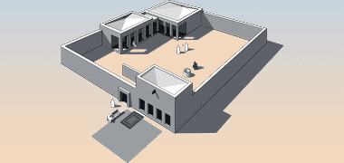
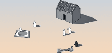
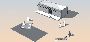
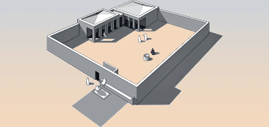
Finally, as illustrated in the two diagrams to the right, the notional development of the courtyard would have seen the development of a majlis within the courtyard, but accessible from the outside. The inside wall would not have openings within it and there would have been screening to preserve the privacy of the household if there was a shared entrance. The majlis was the public arena for the men of the household, both their living room and their face to the world. Sometimes this was developed as a separate structure standing apart from the house wall, but this would have depended on the availability of land, ownership and agreement from the wider family or social group.
Cross ventilation to the family rooms of the development was created by having small openings in the north and west sides – openings which could be readily blocked if driven rain or the shamal warranted it. Simple openings were covered with timber but later versions incorporated naqsh panels with openings carved into them.

This gradual development of enclosed spaces for a growing household produces the open character of compound illustrated in this photograph. It is relatively spacious, there is room for development and there is a clear relationship between the buildings, compound and the environment within which it has developed. But before moving on to the way in which the rooms in traditional houses were used, it might be useful to illustrate the manner in which the above stages of site evolution has seen sites develop within an urban environment. Compare and contrast the feeling within this compound with the more urban development illustrated below, and also note that these buildings in their rural setting are simpler and not as tall as those in urban Doha.

The three sites illustrated in this photograph of an urban corner in Doha bear striking similarities to each other, but are much more restricted, as you would expect, within this urban environment. It is not easy to tell, but I believe they are being lived in by Qatari families rather than having been passed on to expatriate workers as is common practice – this despite the evidence of the concrete mixer parked outside.
Looking solely at the nearest site you can see the majlis in the bottom right corner with its own entrance into a small courtyard which has washing facilities and a small room which I believe will be the kitchen for the preparation of qahwa and shy for those using the majlis. Guests being entertained in the majlis will be unable to see into the courtyard around which the family rooms have been established. There is a similar building on the left of the photograph but I believe that is not the majlis but more likely an addition to the family side of the house. Alternatively, it might be, or become, a retail unit or units.
The family rooms are developed off a raised verandah which provides a degree of environmental control though, at the time the photograph was taken – the mid-eighties – wall mounted air-conditioning units were common. The courtyard is obviously the focus of the family’s life. Chairs are arranged on the verandah, there is a swing, clothes are hanging up to dry and there is a planting arrangement in the centre that appears to be decorative rather than functional. In adjacent courtyards acacciatrees have developed, most probably accidentally.
From their style I would guess the sites were developed in the mid nineteen seventies when this type of sub-division was typical. They are interesting in that they carried forward traditional architectural forms into the new urban areas. In this they were very similar to the traditional forms then being demolished, their main benefit being that they were more generous in plot size than the older sites they replaced.
It is notable that the roof constructions are likely to be traditional as is evidenced by the provision of so many maraazim, the traditional method of shedding rainwater rapidly.
The roof

Elsewhere I have noted that there was not the Western way of naming rooms by their developed purpose, only that rooms were available for whatever function best suited them at a specific time. With the exception of washing and cooking facilities and their, usually fixed, associated locations a room might have a different function by day and night as well as through the seasons. This flexibility extended to external areas of the house plot, particularly the shurfa or verandah with its direct relationship with enclosed rooms allowing activities to extend into or out of a room to the shurfa.


In addition to the shurfa there was a significant space available to many houses, that is the saqf or roof. In the diwania type of building, such as the central building at the development of Sheikh Abdulrahman at feriq al-Salata, the first floor was enclosed by a surrounding verandah. Mathematically, this creates a significantly large usable area compared with the central, closed, area of the building which is evident in this aerial photograph of the central building of Sheikh Abdullah’s development at feriq al-Salata. In the lower photograph, the width of the shurfa is evident with any movement or activities being carried out on the shurfa protected from direct sight from within and outside the compound by a timber screen, painted the traditional blue, and allowing both light and air to benefit those using it.

The first photograph above illustrates one of the more common uses to which roofs were put with the family’s animals – here, goats and hens – being located there in order to free up, and keep clean, the main courtyard and the shurfa associated with the rooms of the main dwelling. The same photograph shows that a degree of privacy was provided by the decorative balustrading which has the effect of providing a form of badgheer to the roof. This device allowed families to move onto their roofs, thus extending the area available to them in carrying out their activities.

Storage and animals were certainly two of the uses to which roofs were put, but they were also a very useful area for washing and drying clothes. It was a very common sight in the 1970s to see roofs used for this purpose, though often the washing was carried out at ground level. The first of these two photographs shows that a number of families used their roofs to dry washing. This practice was also extended to commercial activities. In the lower photograph a local laundry dries its clothes on its roof, the washing taking place in the small courtyard behind the shop.
Traditionally, however, the roof was that part of the compound used for sleeping in the hot months. This was the only part of the compound where there would be air movement likely, hot or not. Actual or perceived body comfort relies on a combination of relative humidity, temperature and air movement. Use of the roof could only come about if there was privacy. For obvious reasons I have no photographs of families sleeping on roofs, but I have seen evidence of its provision in the houses of Qatari families. The badgheer was the architectural device used to create air flow across the roof while giving privacy from adjacent housing. More is written about it on one of the other pages.
This was an area of development covered in Islamic law where neighbours were required to respect privacy. It was an area, too, which was of concern to many Qatari families with their worrying about security for their families, both physical as well as visual. The development of tall buildings gradually eroded the sense of security and privacy enjoyed by those in the older urban areas.

For many of the expatriate community, this concern for privacy was not an issue, and the need for comfort was paramount. These two photographs illustrate something of the tradition. The first photograph shows an expatriate Arab soldier using the roof with no concern for his privacy. He was sometimes joined by his young children, but not by any of the women of the family who, presumably, enjoyed what comfort they could sleeping on the verandah or courtyard.

This photograph, taken adjacent to the Grand Mosque and from its manara, shows how a large group of expatriate workers took to communally sleeping on the roof during the summer months on buildings without any raised parapets or badgheer to provide visual protection. Here, again, there was no concern for privacy and no women involved, so it was not unnatural that they should seek the cooler temperatures to be obtained on the roof – and with the direct influence of sea breezes.
Note in both cases the simple construction of the bed, a common pattern which gained supremacy over the traditional dowshek used by Qataris in the peninsula with its softer cushioning and the ability for air to circulate around the sleeping body.

None of the above photographs can illustrate the actual use of roofs by Qatari families, but they do show how the roof was used as an important spatial resource by both bachelors and families, particularly those living in dense urban areas. Something of the character which might have been developed can be seen in the sketches developed for possible revisions to the Government’s Public House scheme, made in the 1970s, and from which this sketch was developed to illustrate the scale of badgheer needed to give privacy to those using the roof. Here the top of the badgheer is a notional 2.000 metres high, the supporting columns 1.600 metres.
The beauty of the roof space is that it is usually unencumbered by internal walls – other than, in traditional buildings, structures associated with the staircase, if it is covered, and any structure supporting or enclosing water tanks. This allows full use of it to be made with individuals of the family able to select those parts of the roof that are most comfortable to sit or rest in, there being two optimal areas as illustrated here – either immediately adjacent to or a couple of metres away from the surrounding badgheer. It’s surprising how strong the air movement can be as it flows through the badgheer and, as it turns cooler in the evening, this can even feel a little uncomfortable.
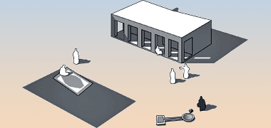
The baraha


This group of photographs illustrate a traditional baraha in front of a majlis in one of the many deserted villages of the peninsula. The feature is essentially an open-air majlis, used when the weather is suitable or when more space is required than can be accommodated within the majlis. Usually this feature operates with rugs on its floor and masaanid around it for the host and his guests to lean on. From the evidence of the site it seems unlikely that the majlis was ever enclosed within a compound. I have the feeling that this was always an external majlis with its associated baraha. The photographs were taken in the abandoned village of Umm Swaijah, a village in the north of the country south-west of al-Khor, which was characterised by the wide dispersal of many of its buildings. The first two photographs were taken in 1972.

A notable feature of this baraha is that it sits right in front of two of the shubabik of the majlis which suggests to me that the owner might have wanted to be able to use the outside as overflow. The majlis is also unusual in that all sides of the structure have windows, albeit one of them – the one facing west – has a single window, that being on the opposite side to the baraha, perhaps encouraging the through-flow of air. In this photograph you can see to the right, in the distance, a second external majlis. This is similar in size as well as having a baraha, but has its interior ventilated by a traditional badgheer system on its west face. Note that rainwater is drained from the roof at the back of the structure with the provision of four maraazim.

Looking even more sad, here is the same building, the photograph having been taken thirty-four years later, in 2006, and illustrating something of the life of this kind of structure. The valuable materials of wood and iron from which the windows and door had been constructed, have been reclaimed for use elsewhere or firewood, and there has been a small amount of deterioration at the corners of the building. The three photographs encapsulate an element of traditional life which has now gone, though continues in a slightly different form.

The photographs above illustrate the simplest common form of the traditional baraha, in those cases ones associated with a single room. But, as mentioned above, this tradition has not disappeared and the baraha continues to be seen outside many properties around the country. In this example, where the baraha has been constructed adjacent to a residential majlis, rolled up carpets can be seen, together with a glass table on which there are some pots. A cable hangs out of the window and is likely to be a television lead from the majlis in order that those using the baraha can enjoy popular cultural and news programmes, keeping themselves up to date with current events. In locations such as this, where the baraha is adjacent to a road, passers-by are likely to drop in and enjoy the hospitality and companionship of the baraha and its activities.
There are a couple more examples of the baraha on the page looking at public housing development.
Room uses

Rooms within a house had no particular designation other than the hamaam, or washroom and the majlis. The hamaam was divided from its adjoining space by a qatiya – a low wall up to head height giving some degree of privacy. Sometimes, as in this example, there is naqsh decoration to the top of the wall. The important point to note is that the qatiya has to be clear of the ceiling as it is imperative in this kind of space that air can circulate.

For this reason there was also a need for air to circulate between rooms in larger houses. This example, again taken in the wind tower house in the centre of Doha, shows how a naqsh panel has been incorporated as a spandrel panel above a doorway. In this way a necessary functional use has been given an attractive, decorative resolution, though I don’t know how effective it would have been compared with the effectiveness of the door below.

Although I have mentioned above the chief specialised rooms in traditional Qatari houses, there was also another room occasionally to be found in houses or their associated buildings when owners grew or imported dates. The mudabissa was a special room set aside for the production of dibis, a strong syrup used to sweeten prepared food. The room typically had no windows as is illustrated in this photograph. The floor was unusual in that it had a series of channels laid to falls created by the construction of hasa and juss ridges about 500mm apart on centre, and 200mm high. These supported a grid or mesh of canes or similar material on which were placed dates with heavy weights sitting on them. The pressure applied released the dibis fro the dates into the channels for collection at the lowest point in the channel system.
It is worth mentioning that there was at least one development which implied there were date plantations in the area, and that was the fortified development at al-Rakayat in the north of the peninsula. Within this development there is a mudabissa – date storage room which is identifiable from the the channels in its floor designed to take the syrup, dibis, from the dates stored above them. It is also possible that the dates brought to the north of the peninsula were from Bahrein as it is only a few kilometres from the coast, and Bahrein had both considerable areas of cultivated date palms as well as using mudabissa as a regular feature of domestic development. There is also a long history of Bahreini interests on the Qatar peninsula, an issue which continued to create tensions into the twenty-first century.
All the rooms could be used for any purpose by anybody within the family, the only restriction being privacy between male and female members of the family, and privacy of the areas containing the families’ normal activities. Cooking was usually carried out within the courtyard or under shade on the liwan. Food was served on dishes or bowls placed on a sufra, or circular woven mat within a room of the house, or on the verandah, depending on the weather and time of day.

Rooms had no specific function apart from the majlis and hamaam and were used by day and night and in the different seasons for a variety of purposes. In some houses members of the family managed to take over a specific room for themselves which was, I suspect, a natural consequence of there being more consumer items around which needed space for storage and use. This photograph shows the interior of a young man’s room in Wakra, taken before it was knocked down for development.
You can see that there’s a problem with storage. Strings have been attached to awatad in the walls from which have been hung clothes, bags and, in the top left corner, a gun. The light source, again just out of shot, was a sixty watt bare light bulb, but bear in mind that other rooms in the house didn’t have electricity and were lit by traditional kerosene lamps.

In this photo of an old internal space the awtad in the walls seem to be made out of old timbers rather than carved or turned wood as is usually the case. They are noticeably thicker than the traditional, turned awtad. This would imply that there wasn’t the time or funds or timber around to make the awtad in a more attractive form, though the naqsh is of a good quality – apparently, in situ – the two panels being symmetrical as was the custom when located at the end of a room and. It also suggests the high value of timber at the time of construction. It is also worth noting that the awtad are designed to project at different depths from the wall to ensure that each hanging cloak hangs free.

This photograph illustrates an attractively turned and decorated watad given to me by a Qatari from the ruins of his family’s house in al-Wakra a long time ago. Generally awtad were between 200mm and 300mm long, of which about 150mm projected from the finished face of the wall. The awtad were turned on a simple lathe and then decorated with primary colours, in this case black and red.
A further development was needed to create the typical spatial form of the traditional houses of this century, and this was the increase in roof span brought about by the introduction of the mangrove poles as ceiling supports. Mangrove was common in the north of the Gulf as well as in the Oman with the influence of East Africa and the Indian sub-continent. Whether or not there was an intermediate stage is not clear but, within Saudi Arabia where mangrove was not available, there is evidence of the use of the trunks of palm trees as beams. These would have been expensive to use and would have implied development of palm trees over a long period of time for there to be a ready supply of their trunks for building. The palm also enables a larger span than the three metres or so seen in buildings spanned by mangrove poles, and I am not aware of any within the peninsula. However, the use of valuable date palms would have been rare. Certainly the strong trade routes to the Indian sub-continent and East Africa made mangrove poles a sensible, if expensive, trade item.
Decorative Arab chests

When discussing the uses of rooms above I mentioned the problem with storage in the old houses. While some items such as outer clothes would be hung from awtad, a more secure development saw the introduction of small but heavy teak chests in which more precious items might be stored. Clothes would be folded and stored in the main compartment with more smaller or more precious items in the drawers. Some of these chests were constructed with secret compartments for small valuables.

This photograph illustrates a beautiful example of such chests. Made usually from teak, they were heavily studded and decorated with brass sheets and handles complete with a substantial brass hasp that could be secured with a padlock. Commonly referred to as ‘Kuwaiti chests’ they probably originated in the Indian sub-continent and I’m told were used both at sea and on land, though their original use is associated with the nawaakhada of trading and pearling craft who had a need to safeguard valuables. Note in both this and the photograph above the distinctive stubby legs which are not usually attached to the chest.

These feet are always of the same character, short and squat and are not usually attached to the chest. The reason for their shape is likely to be the need for them to be movable, self-supporting and stable in supporting the chests. While those above, in the museum appear to have been relatively recent constructions at the time the photograph was taken in 1980, that immediately above is a more expensive version, with greater articulation and brass work decoration. This foot, by contrast, is more like the majority I have seen with relatively sophisticated turning and the application of bands of red, black and yellow paint.

The chests are made of extremely strong materials, commonly of heavy teak with brass hinges, handles and hasps for securing the lid. The hasp was usually cast. Brass sheet and dome headed pins were also used to decorate the chests with simple patterns based on circles, squares and the outlining of shapes as can be seen in the examples here. The lids were held with solid hasps secured with a padlock while the drawers incorporated simple keyed locks. In this photograph a number of brass keys are hung from a chest. While these are not the original keys, they illustrate the size and character of house keys, some of which would have been used for the drawers on the chest.


Generally, ‘Kuwaiti chests’ are relatively commodious, perhaps their size being limited by the need to be able to move them around when necessary. They were produced in a range of sizes, presumably to accommodate the different character and size of items owned by the household, and appeared to have a similar robust construction in all cases. The first of these two photographs shows a medium-sized chest with the traditional three drawers and incorporating a pair of circular mirrors, the latter placed close to the central locking hasp. The size of the second, smaller chest can be gauged by the dellal sitting on top of it. As with the above chest, the mirrors are located closer to the locking hasp rather than equidistant between hasp and vertical edge. The chest has legs, but they were not in place when this photograph was taken. Note that in all cases the lid of the chests oversails by some distance, creating a satisfying topping to the chest.

While the chests are known as ‘Kuwaiti chests’, they are common to all the Gulf states due to their use both on land as well as at sea where they were used by traders travelling between the Gulf, east Africa and the Indian sub-continent as well as others needing a degree of secured storage at sea. To this extent all of the Gulf states associate these chests with their own countries. The design on this postage stamp was selected by Qatar to be illustrative of an element of its heritage, the design being developed from a chest in the Qatar National Museum. Their design varies with the locale in which they were fabricated, this covering a wide area, essentially bounded by at least the Arabian Sea and Gulf.
Toilet accommodation

The rooms in traditional buildings in Qatar were generally multi-use with, as might be expected, provision for cooking and lavatory facilities. Cooking was originally carried out in the open or under a verandah, though provision was soon made for a separate room in which a hearth and storage could be located. With time and house expansion facilities were made available for more storage and accommodation for animals.
Customarily a part of one of the larger rooms – but not the majlis – would be sectioned off by a screen known as a qatiya, behind which a degree of privacy could be given to those using it as a lavatory. Often the screen would be decorated, as in the example shown above, the whole of the room exhibiting the extensive use of naqsh plasterwork. With time privacy and hygiene concerns developed the need for a more enclosed space and, importantly, one connected to a system of drainage. The model appears naturally to have developed from the zuli used on the traditional boats of the region.

Toilet accommodation became increasingly problematic as, for health reasons, it was necessary to move waste away from living quarters and avoid smells as well as ensuring that waste products did not pollute water sources. The general way of effecting this was to provide lavatories which were able to carry the waste immediately outside the building. In this regard they were very similar to devices found on buildings elsewhere in the world and dating back hundreds of years ago.

Generally wash rooms are located as part of a main room, but separated by a qatiya as illustrated above. Where more privacy is required the structure was moved away from other functions of the house. These first two photographs are of a structure, a hamaam – similar in principle to a boat’s zuli – and typical of their design. The room is located on the first floor of a residential building and, I would guess by its construction that it was built fifty or sixty years ago as the cantilevered, squared timbers and planks on which it rests would have been very expensive earlier, and the structure is made with concrete blocks rather than hasa taken either from the desert of sea. There is no fall pipe from this structure which suggests that it might not have been there in the first place, or that it was, and has been removed as the building is in disuse.

Compare the above with these two photographs. The first was taken, I believe, in Rayyan where there are waste pipes, probably connected to a septic tank as it was some time before mains drainage was established and, when it was, this was confined to new building areas. The structure is roofed and ventilation holes have been provided both sides. It is probable that the structure is open on the roof side without an enclosing door. The second example I took in the nineteen seventies, though I don’t recall where. It appears to be a traditional construction, resting on mangrove poles and has a fall pipe to move the waste away.

Even when development standards began to take advantage of more modern methods of construction, some buildings were still designed to incorporate traditional elements and uses. In this photograph, taken within the Inner ring of Doha in 1972, you can see that construction was in concrete blockwork, and that the toilet accommodation was constructed cantilevered off the outside face of the property with cast iron pipes taking the waste, most probably, to a septic tank. There were many buildings constructed in this way prior to the acceptance of different standards, and of mains swerage.

Athough it has nothing to do with the subject of toilet accommodation, I have added this photograph here as it is of the same building and shows the wall treatment at ground floor level. Through the arched openings in the wall a glimpse of the courtyard can be seen with arches containing timber framed doors or windows. It is possible that the windows in the front wall originally lit and ventilated a majlis, though I can’t be certain of it. What is interesting to me is that the wall is of massed construction rather than being columnar with infill, appears to be relatively thin, and has a simple detailing around the arched openings, which are irregular in height and width. It is rendered with a juss mortar, hand finished rather than with a mechanical tool. In respect of its detailing, despite the openings, it somehow seems to have something in common with fortified buildings.
Fortified buildings


Notes on the history page give a brief description of the importance of the Qatar peninsula and the peoples who moved in and around it, eventually settling there, mainly along the coast. While the history of the peninsula goes back centuries if not millennia, those who made their homes there felt the need to be protected both from incursions relating to the tribes who moved in and out of the peninsula, but also from sea-borne piracy. In addition there were difficulties between tribes within the peninsula, all of which created a need for two types of building, those needed to keep watch for predatory movements, and those needed to provide a degree of protection. An extension of this was the threat to the north-west of the peninsula from Bahrain which caused, among other things, the construction of this qal’at, or fort at al-Zubara in 1938, used to garrison a policing force. The two views of it above have been selected as the first shows it without the addition made to its south face – shown in the lower photograph viewed from the opposite side of the qal’at in 1972 – but which has now been demolished. The height of its walls gives a clue to its age; generally, the higher the wall, the more recent the construction – though styling and the materials of construction area also a guide, of course.
There are a number of fortified buildings still standing around the peninsula, mostly forts or watchtowers, but the ruins of others are being researched and, in some cases, reconstructed. The north coast of the peninsula bears the evidence of many of these fortified structures, but there are also substantial buildings on the east coast, as well as inland.
Although there may seem to be many similarities between these structures, it is important to understand that these fortified buildings are not part of a unified protection plan for the peninsula, but are the result of a series of ad hochistorical decisions relating to the fears of the local populations and would have reflected the character and prestige of the head of the local tribe or families who lived there.
Nor would these fortified structures have withstood a serious or sustained attack. Their purpose really was to provide temporary shelter to those policing from, or seeking protection within them, the height and thickness of the walls shielding against small arms fire and, to some extent, against the smaller canons used in the region.
The basic shape of the majority of the qalaa’a was square, or at least rectangular, But it is still interesting to view their plans side by side as in these thirteen illustrative aerial images.


Generally there might be thought to have been an attempt to establish most of the qalaa’a with their orientation towards Mecca – which is found approximately west-south-west of Qatar – but it might also be argued that they were developed with their north walls facing the prevailing wind, the shamal. I have heard both alternatives suggested as rationales.
Here, to the side, are small images of fifteen of the many forts or fortified developments to be found in Qatar. One is very old, nine are relatively old, three are more recent and particularly associated with attempts to control wider regions of the peninsula, and two are reconstructed developments on the east side of Rayyan.
Bear in mind that these qalaa’a were constructed at different times and that the aerial photographs have not been made at the same scales so, in that respect, they can not be compared, the three largest being, in descending order of size, those at al-Rumaillah, al-Rayyan and al-Wakra illustrated, along with al-Kuwt in Doha, in the third of these four groups of aerial photographs.
The first illustration shows, clockwise starting from the top right corner photograph, the qalaa’a at al-Zikrit, al-Freihah, al-Zubara and Umm al-Maa’.
The second illustration shows, again clockwise from the top right corner, the qal’at at al-Wajbah, al-Rakayat, al-Thaqab and al-Zubara.
The third group of four qalaa’a are, again from the top right corner, those at al-Rayyan, al-Wakra, the qal’at in the centre of Doha – known as al-Kuwt – and al-Rumaillah, for many years the main centre of policing.
The last of these images, and again clockwise from the top right, shows the plan of the oldest fort in the peninsula, dating back to the ninth century, that at al-Murwab, and two of the reconstructed fortified developments in Rayyan.
This list of fortified structures is not intended to be exhaustive and contains developments of very different states of preservation. This map of the north of the peninsula accompanying it is not intended to be accurate, nor are all the places referred to below on it due to a lack of information. As always be aware that there are often a number of different transliterations for names in Qatar. The map will be updated as and when more information is uncovered but may be compared with the map that is located on the history page, though neither map can be guaranteed accurate. More precise references are given for some of the locations on the geography page.

- Bida – burj al muraaqiba, reconstructed.
- Bir Hussein – qal’at in the north of the country of which little remains.
- Doha – qal’at working development at al-Rumaillah.
- Doha – qal’at known as al-Kuwtadjacent to the central suq.
- Freihah – qal’at 3.5 kilometres north-east of al-Zubarah. Perhaps founded around 1850.
- Ghuwair – qal’at in ruins around 85 kilometres north of Doha.
- Khor – burj al muraaqiba, reconstructed.
- Murair – qal’at east within al-Zubara village walls and 2 kilometres south-east of the port at al-Zubara.
- Murwab – qal’at near the west coast of the peninsula. The oldest fort in the peninsula dating back to the 8th or 9th Century.
- Rayyan – qal’at in the centre of Rayyan facing the junction of the road linking to the Salwa road.
- Rakayat – qal’at 2.5 kilometres north-east of qal’at al-Thaqab.
- Ruwaidah – qal’at on the coast a few kilometres south of al-Ruwais.
- Shaghab – qal’at around 110 kilometres north-west of Doha.
- Thaqab – qal’at 9 kilometres north-east of the qal’at al-Zubarah. Founded in the 19th Century.
- Umm al-Maa’ – qal’at near the west coast of the peninsula of which only foundations remain.
- Umm Salal Muhammad – fortified structure around 17 kilometres north-west of the centre of Doha.
- Umm Salal Muhammad – barzan reconstructed watchtowers.
- Wakra – qal’at a hundred metres west of the main road passing south through the centre of Wakra.
- Wajbah – qal’at around a kilometre south of the Dukhan Road just west of Rayyan.
- Yussufiya – qal’at in the north of the country of which only foundations remain.
- Zikreet – qal’at 10 kilometres north-east of Dukhan of which only ruins remain. Perhaps founded around 1810.
- Zubara – qal’at 2 kilometres east south-east of al-Murair. Constructed 1938.
Fortified buildings in Qatar appear to fall into three general groupings:
- buildings constructed specifically as fortified structures, usually within the colonial period,
- those that developed a fortified character for protection, and those
- developed to provide a surveillance function.
al-Murwab

The oldest fort discovered in Qatar is that situated a al-Murwab in the north-west of the peninsula. Situated around 4 kilometres from the coast, 4.6 kilometres west-south-west of Umm al-Qubuwr – itself around 2 kilometres west-north-west of the present-day settlement of al-Nu’man – and 12.5 kilometres south of Zubara, it has been dated to the Abbasid period. The settlement with which it is associated is thought to have been continuously occupied for over a hundred years around the ninth century. Just as important is the fact that this was a considerable settlement situated inland and not on the coast. This aerial photograph of the fortress was taken from the south-east. Its entrance is on the north face and its west wall is oriented roughly in the direction of Mecca.
The settlement was organised lineally in five loose groupings totalling around forty-one houses – themselves comprised from around 240 rooms – and included two small masaajid and a number of graves, with the fort a little way to its north, its entrance being on the opposite side from the settlement. The village was spread over an area of approximately 1.4 kilometres by 0.5 kilometres taking advantage of its location within a shall declivity supporting plants in its rawdha deposits. Traditionally this area of the peninsula was used by the Na’imi tribe for winter pasturage.
There were a small number of additional settlements located nearby. The settlement at Umm al-Qubuwr incorporated a large warehousing facility which was associated with dwellings in the Abbasid period and, around 2 kilometres south-west of al-Murwab, was another Abbasid settlement of a few houses, similarly laid out to al-Murwab and including a well that is still in use.
The original fort was destroyed by fire and replaced by a slightly smaller version, as can be seen in the photograph above, but retaining two of the original walls on the north and west. The construction was of limestone hasa with circular towers at each of the corners together with a number of semi-circular towers along the external faces of the walls. Spaces for accommodation and storage, comprising a series of rooms each having access from the courtyard, were constructed against its north and west surrounding walls. A well still exists, contained within the structure in its south-east corner.
Despite the importance suggested by its age, location and settlement, al-Murwab appears to have been abandoned for centuries and does not appear in Lorimer’s Gazetteer suggesting that it retained no significance to those living in the north-west of the peninsula.
It is also worth bearing in mind that in and around permanent settlements such as al-Murwab, there would have been temporary dwellings associated both with seasonal travel as well as with the flexibility that these structures present.
al-Wakra

The first type of fort is characterised by the forts at al-Zubara, Doha and Wakra of which the latter has the most developed corner towers. The Wakra qal’at – here looking at its west-facing wall with entrance – was large compared with the others. It is named after Sheikh Abdulrahman bin Jassim al-Thani who, historically, controlled the town and its port, but I believe that this version of the fort was constructed some time after the nineteen-forties as an early photograph of around that date shows it in a different form.

Even though Wakra was an important centre for urban development, its size – as can be seen from the length of this wall – and location well away from the housing on the coast suggests a relatively late date for building. The length and character of the wall is the most important feature to note. An interesting aside is the painting blue of the shurfa which might have something to do with visual effect formed when long horizontal walls meet the sky.

This detail of the qal’at at Wakra exhibits a feature that I have not seen elsewhere, a form of projecting machicolation that seems to have a relatively limited function. The tower is the same tower as that illustrated in the two photographs above. It is evident that the design above the siqaataat has been amended. There are two levels of fat’ayyin or ’ayyin from which to look out of or shoot, but although the inside openings are relatively wide, they constrict use and are favoured to support shooting straight ahead. They have only a limited scope to permit enfilade fire, protecting the face of the building.
However the projecting machicolation feature does allow the defenders to deal with anybody who gets below them. This is one of the key points to attack buildings constructed of desert stones and so is usually thickened as can be seen at al-Zubara in the photograph below. In this case the walls are taken straight down to the bed rock and reliance placed on the defenders having direct sight of anybody attempting to undermine the wall. Note also the relatively high shurfa which seem to be a feature of fortified buildings, lower versions being more typical of ordinary buildings.

This photograph, taken in 1981, is of the north-west tower and can be seen to be different in certain respects from the south-west tower illustrated above; yet it is not possible at this distance in time to understand why this should be so. It is the same tower as features in the first two photographs. Generally alterations to fortified structures relate to improvements in defence strategies and weaponry. Here there is unlikely to have been changes in these between the times the two towers were constructed. The apparent differences in level between the bottom of the siqaataat and the top of the wall in the last two photographs are due to the west wall being higher than the north wall. The differences in the treatment of their siqaataat and shurfa is irrational and does not accord with the general principles requiring adherence to the original designs in restoration.

In common with most forts, one of the corners of the development would have incorporated living quarters for those garrisoned there. At Wakra this element of the development was located in the south-east corner and, in this photograph taken in 1978, shows that the structure was developed outside the line of the walls to provide a verandah. There is even the hint of a classic pediment added. Otherwise it is likely to be much as it was constructed in the middle of the last century.


In common with many buildings of this sort, the entrance gate within the west-facing wall has a religious exhortation carved into a decorative naqsh panel over it. The shape of the panel and its supporting carving have been crudely derived, perhaps from the decorative feature found within the angle between columns and beams of a traditional Qatari iwan. But the cursive S-shaped elements to the side are more interesting, suggesting double-ended shooting stars.
Within the panel, the reflected six-pointed star and crescent are a common decorative feature on buildings and can also seen as the top finial on abraaj. As for the inscription, it is verse nine of the thirty-sixth sura of the Holy Quran and, below the bismillah, centred at the top, reads:
and We have put a barrier in front of them and a barrier behind them, and further, We have covered them up; so that they cannot see.
It is not clear to me why this particular verse should have been selected for a fort, but the verse refers to people who neither listen to reason, nor have a correct appreciation of their surroundings. Thus they can neither take to the right path, nor can they take into consideration the historical evidence around them, from which they could draw some lessons from past episodes.
The inscription is poorly set out and contains two spelling mistakes suggesting, I am told, that the carver may not have been an Arab or Muslim.

Here, in a photograph taken in Wakra in April 1979, is a novel development of the shurfa design seen above. There are many differences from traditional details, but the design retains the character of traditional architecture in the peninsula. The two string courses immediately below the shurfa are unusual as the shurfa is generally a continuation of the vertical wall plane on a fortified building from which this detail might be thought to be derived. However, the use of a similar, but smaller string finish was found in ordinary buildings in Wakra. Colouring the panels has emphasised the design and this has been reinforced by the incorporation of both a circular globe and a vertical strip light at each corner creating a more formal completion to the roofline.

The second type of structure – fortified housing – can be found at Umm Salal Muhammad and Doha. Umm Salal Muhammad is, however, a special case as there is both fortified housing there as well as two watch towers, though the latter are a little over eight hundred metres due east of the fortified house. I believe the latter, erected outside the town, were constructed as watch towers and, for whatever reason, didn’t have the need to house a large military presence. As a consequence they don’t have the large footprints of the al-Zubara and Doha forts which are essentially protected courtyard developments. The fortification of this building is likely to be related to its position directly adjacent to an oasis of palm trees to its north and west, and a large water catchment to its east. This view of it is from roughly the north-west.
There is a little more about the fortified house at Umm Salal Muhammad lower down the page as well as about the Barzan towers.

The courtyard type of development was constructed in a more secure manner with particular attention being paid to the weaker points of the structure. This typically created tall circular towers at the corners of the structure to give improved security. It might be thought that the corner of the qal’at that doesn’t have a projecting tower on it – that on the right of this photograph – is in more danger, but its two adjoining corner towers provide enfilading fire should attackers attempt to breach it and, as mentioned below, one of the sides had a single siqaat on the far side.
The reason for the rounded corners is that the desert stones with which walls were constructed are relatively small and irregular, making them difficult to bond together, particularly at the corners. There was no attempt to trim the stones to regular sizes, squaring them up. Because of this corners of small buildings were reinforced internally with mangrove poles across the angle and, where the walls were defensive, the solution was to thicken and round the corner, giving no easy point to attack.
al-Zubara

The first of these photographs was taken from a Ministry of Information funded book, Qatar, and illustrates how the fort at al-Zubara appeared in 1972. The aerial photograph was taken from, approximately, the north-west and shows on the far side the extension for accommodation to the east of the fort which was constructed, I believe, in the 1960s for Police operational purposes, and later removed allowing the fort to be seen, again, as it was originally constructed. The helicopter pad seen at the top of the photograph has been moved to a position due east of the fort. The entrance to the original building can be seen immediately adjacent to the rectangular two storey construction.

This is a photograph of it I took of the fort in the mid nineteen-seventies when it had a more modern security function. The view is from the south-east. Although there is a square-sided structure comprising a part of the structure, the main towers are rounded and battered and of considerable depth to provide strength. An additional feature of the towers is their being reinforced at their junction with the ground, a feature both helping to resist a possible mechanical attack as well as dealing with weakening by water ingress. It is also worth noting the extent to which the towers project from the main walls of the structure. Internally this allows a small entrance to the towers from the first floor parapet, while giving a greater periphery from which to observe and defend the building. More has been noted about Zubara below.

Internally, the main accommodation is provided as peripheral structures which form the floor of the parapet from which watch could be kept and the fortress defended. The ’ayyin can be seen clearly and look relatively sophisticated in their three-row arrangement. It should be noted that they appear to be organised at heights suited to men operating firearms kneeling or standing, and that there is a continuous ledge which I assume has a purpose either for steadying the kneeling man’s rifle, or for temporary storage. I don’t think it was necessary for strengthening purposes, the other obvious possibility.


The first of these three photographs, that above, shows how the interior of the building was in the early years of the twenty-first century where it is evident that alterations have been made to the character of the peripheral accommodation, though I don’t know why. The second photograph shows how the same view of the courtyard appeared in 1989. Note that a part of the surrounding accommodation, on the right of the photograph, has been demolished in the first photograph. I would have thought this would have been more like the original design.
The third photograph shows the arrangement for the entrance to the fort, illustrating the rationale for the squared tower which housed and protected those guarding the entrance gates to the interior of the fort, compared with the circular towers which were more strategic in their defence rationale. Surprisingly, you can see that shurfa, enabling guns to be used against attackers, do not cover the entrance gates, the south wall of the square tower – on the right – being constructed flush with the front surrounding wall to the fort.

At the top of the squared and circular towers there are three common elements of fortified architectural vocabulary to note. The first is, perhaps, the most commonly noticed on fortified buildings, the shurfa, or crenellation along the top of the walls of the four towers. The purpose of these is to provide a degree of protection to a man standing and using a gun in the embrasures, the spaces between the crenellations. This photograph shows shurfa on top of one of the circular corner towers at al-Zubara.

The second element is also very common, that is the fat’ha al murakaba which enable guns to be deployed against attackers at a distance. Traditionally these are circular but there are also vertical slots which allow some variation in the elevation of a gun, but not good lateral movement. Bearing in mind that the walls are relatively thick and the holes relatively small, it must have been difficult to find a target and take accurate aim through them.

The third element, shown from the inside in the photograph above and, here, from below outside, are the shurfa or machicolations. These are usually horizontal holes in the extensions of the internal floor, devices designed to allow better control of attackers immediately outside the wall, enabling defenders to look and shoot downwards, thus protecting the foot of the wall. These two photographs illustrate the normal range of fortified wall elements designed to help protect the defenders of the building.
These next two qalaa’a are similar in that they have both been re-built or reconstructed. The forts at al-Thaqab and al-rakayat are, like most of the other forts, situated in the north of the peninsula. Their reconstruction has been partly based on policies relating to preserving something of the past but also having in mind the educational and touristic possibilities emanating from it.
Significantly, both qal’at appear to be designed to house a relatively small garrison as the walls have no access at high level from which defenders might defend the structure. Nor are there ’ayyin within them at ground level for the same purpose. All provision for observation and defence is concentrated in the corner abraaj where enfilading fire can be brought against anybody coming close to the sals.
al-Thaqab


These five photographs are of the qal’at at al-Thaqab. Three of the corners of the qal’at are fortified by short towers which each take a different form. Why this is so I am not sure. Those on the south-west and north-west are circular, the former larger than the latter, and the south-east corner has a small rectangular form. The first two photographs illustrate how access to three of the corner abraaj is effected with simple stairs and then a ladder to the upper observation and defensive positions. The main entrance to the qal’at is from the north, adjacent to the north-east corner where a tower is raised above the ancillary accommodation for those posted there. The tops of the walls have a rounded finish to them, presumably to increase the difficulties for anybody attempting to gain a purchase for mounting and overcoming the wall.

Nor am I able to comment on the arrangement and architectural character of the ancillary accommodation other than to suggest that it has a modern appearance to it. Certainly the general structure appears to follow the more recent historical practice in the peninsula, if not the region, but the construction seems to be too regular and the finished texture wrong in that it is too rough. The windows are set higher in the wall than I would have anticipated for an old structure of this sort, and the location of the maraazim also look unusual in their placement relative to the structure.


The fourth of these five photographs gives a good idea of the view the sentries or defenders would have had over the surrounding approaches to the qal’at. The shurfa are designed to give a degree of protection to defenders and enable them to deploy weapons – guns or rifles – against attackers. The ’ayyin are always an interesting feature. Qataris have told me that they are there to enable guns to be used against attackers, but the holes rarely seem large enough to do so effectively. In any case they are relatively small and do not allow the lateral or vertical movement required to follow a moving target. The shurfa are far more effective for this purpose. In this photograph the positioning of the ’ayyin with respect to the The shurfa seem to be irrational.
The last of these five photographs show that one of the ’ayyin appears to have been fashioned with the capability of looking down at the ground close to the walls of the qal’at. This particular ’ayn overlooks the area immediately outside the entrance gate.
al-Freiha


The qal’at at al-Freiha is similar in many ways to the others dotted around the north of the peninsula, though there appears to be on significant difference when looking at this aerial photograph of its ruins. There is obviously a rectangular structure at the bottom left corner of the development – in reality, its north corner, the structure being set almost diagonally north-south – with the other three corners appearing to have rounded structures. But at the entrance, from the north-east, there appears to be a room projecting into the centre of the enclosed area, this being different from many of the other structures where all rooms are constructed against the surrounding and protecting wall.

Although it is not a fortified structure, I have added an aerial photograph of the masjid at al-Freiha as it is interesting to compare it with the probable arrangement at al-Rakayat, below. The masjid at al-Freiha is around fifty metres to the west of the qal’at, immediately adjacent to the bay, just out of picture to the right of the photograph above of the fort ruins. It is a five bay structure with an internal row of columns and an external porch. It is not possible to be sure from the photograph if the excavation in its south-east corner suggests a burj was located there, but it appears that there was accommodation for wudhuw’ in the north-east corner.
al-Rakayat


The fort at al-Rakayat is similar to that at al-Thaqab in certain ways, but there are significant differences. Both are rectangular and incorporate the necessary corner towers. However, the qal’at at al-Rakayat has only a single circular tower compared with al-Thaqab’s two, but it is large and situated in the south-west corner of the qal’at. The second photograph looks towards this tower within the compound while the first photograph shows the character of the fort from the outside, looking towards the north-west corner and illustrating its squat character. The most notable differences between the two qalaa’a is that al-Rakayat has accommodation built into three of its walls – those along the west, north and east ̵ and that the walls and towers at al-Rakayat are slightly lower. Also note that the south wall, on the left, is lower than the walls in which there is accommodation.

The second photograph looks back towards the north-east corner of the qal’at. It is not possible to see in this photograph, but this tower only allows enfilading fire along the east wall, whereas the towers on the north-west and south-east corners of the qal’at permit enfilading fire along both their adjoining walls. The north wall has the remains of walls projecting into the compound which would have broken down the space within the qal’at into two different-sized areas, the smaller to the east.


Curiously, there is a single room located outside the qal’at and close to its south-west corner with its incorporated tower. In defensive terms this makes no sense, so initially I assumed it to be a later addition to the complex. However, looking closely at the aerial photograph it appears to be a The masjid. Constructed of hasa rather than of a less durable material suggests that the building was considered to be important. Note that the shape of the The shurfa differs between the two qalaa’a, and that access to the corner tower leaves defenders exposed. It is interesting that the masjid is constructed outside the qal’at rather than inside as is the case at the Kuwt in Doha. I should also note that the first of these two photographs was taken in April 1989, and the second, I believe, around twenty years later, although they appear to be contemporaneous.

This photograph is of the external corner of one of the rectangular corner towers, probably that in the north-east. It illustrates that this structure was constructed of mud bricks rather than of desert hasa. The walls of the qal’at have been treated with the usual juss which has been given a smooth finish. As can be seen, the bond between the structural material and its cover has broken down. Perhaps this is due to a combination of two reasons – the different character of the two materials, and the lack of a good mechanical bond between the two.
al-Wajbah

The fort at al-Wajbah is interesting in many ways, not least because it was the site of an extremely significant battle in the history of the peninsula. Situated around twelve kilometres west of the coast at Doha, it had a commanding position on a slight rise overlooking a depression to its west, the location allowing a significant amount of control on passage into and out of the north of the peninsula while enjoying a degree of isolation from the littoral conurbations of Doha and al-Bida and their garrisons.

Perhaps because of this strategic importance it can be seen from this photograph that it was a substantial fort with one of the highest, if not the highest walls and corner towers in the peninsula. I am unable to state how it was originally formed as it has been extended, but in its present state the original, southern, square part of the fort has rounded towers at the north-west and south-east corners with a square tower coincident with the wall in the south-west corner. Nor am I able to say where its original entrance was, though my guess would be the south side, the entrance usually being close to the accommodation provided by the rectangular structure.

In the north-west corner of the existing fort a masjid has been built and incorporated into the fort with, in the north-east corner, an enclosed more modern structure also created within the overall, extended walls of the fort. The lower part of the mihrab has lines etched into the juss finish of a shape and pattern replicating the concrete blocks commonly used from the nineteen-fifties onward, which suggests that the masjid might have been added some time after 1945. There would have been a masjid or at least a nominated prayer area associated with the fort, and this might have been outside its protective walls on the location of the present masjid structure, this replicating the positioning of the masjid at al-Rakayat, above.


In the walls running around the top of the fort were a series of observation holes at, more or less, eye level, but there were also holes for rifles – ’ayyin or fat’ha al murakaba – which, due to the thickness of the walls, did not permit free traverse for rifles, but individually concentrated on overlapping arcs of fire. These ’ayyin were located at two lower levels allowing defenders to lower their rifles to shoot at targets nearer the wall. Holes in the corner towers gave good sight along the length of the walls, facilitating enfilade fire, and devices were also introduced which created larger, triangular apertures, in effect, siqaataat, overlooking the gateways and any activities concentrating at the foot of the towers. Good examples of these can be seen at the al-Zubara fort. However, it should be noted that the development of an architecture specifically supporting enfilading protection was not reflected at al-Wajbah, nor in the other forts in the peninsula.

While the tops of the surrounding walls had no decorative or defensive elements other than ’ayyin, the two towers were finished with shurfa which would afford a certain degree of protection to guards on duty in them. This view was taken from the top of the tower in the north-west corner towards that in the south-east corner in 1986. The western edge of the town of Rayyan can be seen in the distance, around three kilometres away.
These forts were important structures in the history of the peninsula. While the smaller examples in the north of the country retain something of their individuality as they stand with no development surrounding them, the forts at Doha, Rayyan, Wajbah and Wakra now have development relatively close to them, making their raison d’être more difficult to understand in the context of the history of the peninsula.
al-Rayyan

This may not be a qal’at in the sense that is used for those above, nor is it the Rayyan qal’at referred to above, which is a more modern construction. This is an old fortified residential development which has incorporated aspects of qal’at design in its walls. The photograph was taken at Rayyan in June 1973. The walls of the development are relatively tall compared with those of the qalaa’a in the north of the country, though they are similar in height to the walls of the qal’at at al-Wajbah situated around three kilometres to the west. They look higher in this photograph as the first floor structure and its badgheer extend the wall’s height. This first photograph of it focusses on one of the rear corners of the development, showing a round corner tower. This tower is located diagonally opposite the round corner tower seen in the photograph below.
Nearly fifty years later I had thought that I would no longer be able to identify this development, but I am now certain that it was the development marked as ‘A’ on the map shown a little way below. The difference between this development and that next to it can be seen in the relative shapes of their circular corner towers, the larger development, ‘B’, having vertical walls while this development, ‘A’, has battered walls – though a reinforced base has been added to ‘B’ since the aerial photograph was taken.

On the intervening corner there is the first floor development seen on the right of the photograph above and behind the front wall on this photograph. Note that the two round towers have their bases treated differently. The probability is that the fourth corner, out of picture right, would also have had a round tower incorporated into it, but subsequent development has altered the appearance of the compound, perhaps as a result of the lack of need for this amount or character of protection.

This photograph, taken in June 1975, shows the compound under renovation and repair, this being an internal view of the tower in the photograph above. The wall on the left abutting the tower can be seen to have the traditional hasa and juss construction, but the wall on the right has been strengthened with a cement mix, this being the way in which early restorations were carried out. The construction of the corner tower is clearly shown with the shandal projecting from the face of the burj and the single access to the interior standing at raised ground level. It is evident that a cement mortar is being used in the repair or reconstruction of the wall in an attempt to strengthen it, whereas it appears that the burj retains the traditional juss finish. There is another image of this complex below after the work was completed, and with a little more commentary.
One significant design item to note is the extent of the ayyin in the tower compared with those in the al-Wajbah qal’at. Here there are considerably more ayyin at the lower level suggesting either that the builders were considering a greater threat level, or that the builders at al-Wajbah were concerned not to allow attackers to have easy access to ayyin at ground level.

The lower photograph illustrates work proceeding on the residential element of the compound. The iwan treatment is typical of this type of development, a similar arrangement being found at the fortified residential compound at Umm Salal Muhammad though, in the latter case, the columned arcade is much taller. At first floor level, the badgheer screening is partially complete and further work went ahead to complete the restoration along with carved juss decoration.
There are more recent photographs of the completed complex below.

This photograph is of the large fort at Rayyan, and was taken in May 1934. The larger photograph from which this detail was taken can be found on one of the pages looking at old photographs of Qatar. While this fort does not have the antiquity of the fortresses shown above, it follows similar principles of design. The development was constructed in the 1920s and was developed for the ruler at that time, Sheikh Abdullah bin Jassim al-Thani.


The original development had its footprint expanded when a large majlis was added to the north. In the early 1960s Sheikh Abdullah’s grandson, Sheikh Jassem bin Ali al-Thani, inherited the development and demolished much of it, rebuilding with blocks and cement and having it supplied with electricity. In 2004 that development was itself demolished and restored to an appearance of its original architecture. This lower photograph shows the east face of the new development, the project now unoccupied and fenced off. On the right of the photograph the majlis extension can be clearly seen set on the north-east corner of the older development. This restored development is shown as ‘B’ on the map here, to the east of Rayyan. A related development, ‘A’, is also discussed in a little more detail above and below.
It is evident that the development was not fully defensive as there are a number of rooms with windows opening at ground level, most them relating to a majlis. In this sense it has much in common with the fortified compound at al-Wakrah, above. Nevertheless there are two circular watch towers constructed at the north-west and south-east corners of the perimeter, that on the south-east corner allowing enfilading fire across the main entrance to the compound which is from the south, left, side of the development. There is also an extension in the original development outside the north-west corner of the compound which has a circular construction on its north-east corner. This appears to have gone in either the 1960s or 2004 amendments to the development.

In the aerial photograph of the large compound at Rayyan shown on one of the pages relating to the old developments in Qatar – from which the detail image above was taken – there is, towards the top of the photograph, a small development a few hundred metres to its north-west and immediately to the east of a large walled garden area. It is not possible to get better detail than this enlargement from that photograph, but note that, in the south-west corner of the development there is a square-built tower almost wholly outside the main compound. I would have to believe it is there for a defensive purpose, or at least for observation over the garden and surrounding desert. There appear to be no similar towers in the sprawling development that can be seen to the south of the large compound suggesting that this landowner felt some degree of isolation and a need to protect his own property, yet on a much smaller scale than the fortified towers looked at below.
Looking over today’s maps of the area there appears to be no corresponding development relating to the footprint of the compound, though is possible that the planting, or at least a part of it, may remain, now enclosed within the area given over to the Education City male housing compound – though in 2020, one map shows it gone.
It is worth noting that there are a number of fortified domestic compounds similar to these in the peninsula, some of which are looked at below. Note particularly those at al-Adhbah and al-Markhiyah.
Umm Salal Muhammad


The shurfa, illustrated above, are of a functional design and would have provided adequate protection to defenders. But later, and elsewhere in the peninsula, these shurfa became more decorative, many of them at the expense of providing a realistic degree of protection. Here, at Umm Salal Muhammad, a far more decorative shurfa was used, incorporating into each upstand an unnecessary ’ayyin which can be clearly seen in both these photographs. Notice that, on the left hand side of the upper photograph and between the maraazim, there are vertical slits in the roof parapet which would have enabled seated riflemen to operate. Those at the higher roof level are extremely unlikely to have been usable and should be regarded as decorative.

Compare the shurfa above with this example, photographed at al-Wajbah, looking diagonally across the fort from one of the towers. Here, the shurfa provides a reasonable amount of protection to anybody behind it, the embrasures between the crenellated elements sufficient in size to provide adequate observation as well as optimal handling, both horizontally and vertically, of a firearm.

Also at al-Wajbah is this detail, one which makes considerable sense in a defensive rôle. In this fort, the defensive wall is taken at 135° to meet the circular corner towers in the form of a shurfa or machicolation. This allows observation from above and a counter-attack on anybody attempting to damage the tower at its foot, as well as incorporating ’ayyin at shoulder level for use with a firearm.

One of the important design decisions in fortified structures revolves around the means by which people within the building obtain access to upper levels. Here, at Umm Salal Muhammad there are external staircases where those using them will be at some risk from attackers. This example is on one of the two fortified buildings in the settlement, but there are also more open staircases, shown below, on the barzan where those using them might be at significant risk.

Generally, in fortified buildings, defenders are well protected by the nature of the design and construction of walls and containing towers. Access to elevated walkways are nearly always by open staircases, but they are out of sight from attackers and, therefore, only liable to injury accidentally. Where access to the corner towers was not from an elevated walkway, it was either made by rope or by means of a ladder. This latter might take the form of a loose ladder which, like rope, has the benefit of being drawn up behind the defender, but more often the ladders were built into internal corners of room, a way both of strengthening the structure as well as of providing secure hand and footholds. This example was photographed in one of the fortified buildings in Umm Salal Muhammad.
al-Kuwt fort at Doha
The first point to make here is that it is probable that al-Kuwt borrows its form as a fort, qal’at, but performs the role of a police post, zabtiya, a Turkish or Ottoman word not commonly used in the Gulf.

One of the first fortified structures that visitors are likely to see when they come to Qatar is the fortified Turkish structure in the centre of Doha, known as al-Kuwt. Originally constructed in the 1880s, the present structure dates from 1927 when it was re-built after falling into a degree of disrepair following its being abandoned by the Ottomans in August 1915 as a direct result of the previous month’s Anglo-Turkish Convention. This aerial view was made in October 1972, looking approximately south-east, when it was unused, and following its use as a police post and prison.

This photograph was taken in March 1972 looking south along its west face, the rear wall of the fort. As can be seen from the photograph above, the entrance to the fort was from the east, the face that overlooked the centre of Doha and its suq. In common with most fortified structures, the entrance door was small with an inspection window near it. Whether this was a feature of the original structure, I have no recollection, though I doubt it. The door was not centred in the wall but was nearer the south-east corner than the north-east corner.

In common with the fort at al-Zubara, this structure had its corners protected by three circular towers and one rectangular tower. However, defying good military practice, the rectangular tower does not project from the faces of its external walls, meaning that any enfilading fire needed to protect the building against attackers close to the walls would only be possible from the circular towers at the opposite corners of the fort to the rectangular tower.
Compared with the tops of the corner towers, the top of the walls of the structure are level and not treated with shurfa to give a degree of protection to defenders on the wall. However there are holes – fat’ayyin or ’ayyin – in the walls of the towers looking both horizontally and vertically, allowing the defenders some capability to defend themselves while being protected from attacking fire.

Since the photographs above were taken, the building underwent a significant change, though I don’t know the date this work was carried out. Large entrance doors were added to the western face along with windows adjacent each side above which are naqsh panels. Fenestration was also developed at high level in the rectangular tower in the north-west corner of the building. Compare this photograph, taken in January 2002, with that two above, taken thirty years earlier in March 1972.

This detail is of the top of the rectangular corner of the structure, illustrating the shurfa and ’ayyin. Although there are the same number of maraazim, one of the ’ayyin was omitted for no clear reason. More articulation was given to the planes of the façade and a significant amount of naqsh added to many areas of the structure’s façade. Its character was completely changed by these architectural interventions, alterations that are radically different from those employed at the fort at al-Zubara which was also developed as a museum.

The detailing of the west façade of the fort changed its appearance of functional honesty to one of pastiche when compared with al-Zubara. As in so many examples where there has been redevelopment of traditional buildings, the opportunity has been taken to over-embellish. Not only is there extensive treatment with naqsh, but some of the details are incorrect. For instance, this mirzam is not set in the correct position. An interesting feature is the use of the Egyptian-styled capitals adjacent to the entrance, a feature that has some history in Qatar. While the naqsh treatment over the windows may be reasonable, the extensive use and scale of it over the entrance gates seems out of character to the historical use of this form of decoration.

It seems there may have been reservations about the way in which al-Kuwt had been redeveloped for its use as a museum. This photograph is of the west façade of the building as it appeared in August 2008. One of the ’ayyin of the left, rectangular tower, is still missing, as are many of the maraazim of the main wall. In fact the two ’ayyin are not in their original positions either. I believe this is how the building appeared at least in March 2012. It is no longer used as a museum or a place for exhibitions.

While the structure has been returned to something approaching its original condition, small but significant interventions have been made to the building which have detracted from its historical meaning and character as well as its representation of a fortified structure. For instance, a wall has been added, extending from its northern face to form part of an enclosure. Normally you would anticipate that a military or police structure would stand clear of ancillary structures and, if this was necessary to accommodate a new enclosing function, it would be detailed as a separated element from the building.
In addition to this, a projecting ledge has been added at the change in vertical planes of the corner towers, presumably to accommodate lights that might add interest to the building at night. Regrettably this conflicts with two elements of the traditional architecture.


Firstly, this feature diminishes and interferes with the original design function of the vertical ’ayyin immediately above it. The ledge partially blocks the vertical view to the foot of the wall and of any attacker who might have reached that position. This, like many modern interventions, reduces the potential instructive benefit of the traditional structure.
Secondly, the ledge incorporates the maraazim on all the towers, creating a feature that is not found in the traditional architecture of the peninsula. There seems to be no good reason why the lights, if really needed, might not have been placed immediately below the projected top element of the wall. Or, if the new projection was required, why it could not have been located immediately below the row of maraazim. Preferably, it should just have been omitted.
Incidentally, I forgot to mention that when the structure was originally restored, the number of crenellations articulated in the shurfa of the rectangular tower was increased from ten to twelve on the west and east faces, and from four to six and then seven on the north and south – excluding the corner articulations. And, while I have referred to it in this note as a tower, it has always been a windowless room with two doors’ access from the wall’s surrounding fire step. It is probable that there would have been a traditional corner access from within the room to its roof for maintenance and defence.
In addition, although I don’t know when the work was carried out, I believe that the window to the left of the entrance door, when viewed from the outside, was moved and the doorway slightly enlarged and, perhaps also moved a small distance north along the east wall. However, I am not absolutely certain of these two assertions.
Fortified domestic buildings

The fortified building at Umm Salal Muhammad would have been constructed both to protect passage within the peninsula as well as give protection to the water and associated planting at the north of the settlement. This aerial photograph, taken from the image by Bernard Gérard in a Ministry of Information publication, shows the settlement from approximately the south-west with the newer development to the south, nearer the camera, and the fortified building in front of the palm trees, top left. The image was taken in 1972 and the road to the north is off picture to the right.

The residential development at Umm Salal Muhammad was an important complex. Established in a strategically important position approximately in the centre of the peninsula, it commanded views east and west. To its west was one of the main routes to the north-west corner of the peninsula where there were a number of historically important settlements. This aerial perspective illustrates the development from, approximately, the north-west, its long wall facing the shamal, so providing a degree of environmental protection to those living downwind of it. The illustration shows a little of the cultivated area established on the rawdha that was found there together with its associated wells. The main part of the development was probably the largest of its sort in the peninsula, certainly having the tallest construction. Around it were associated single storey buildings, mainly used for living quarters and storage.


Here, photographed in January 1976 at Umm Salal Muhammad, is an example of the second type of structure – a fortified domestic building, the side facing south-west, seen here, shown from the adjacent cultivated gardens. There were two of these structures at Umm Salal Muhammad, constructed in 1910 by Sheikh Muhammad bin Jassim bin Muhammad al Thani. Nearby, another settlement was developed by the brother of Sheikh Muhammad, Sheikh Ali bin Jassim bin Muhammad al Thani – Umm Salal Ali.
This structure is the larger of the two built by Sheikh Muhammad. As it was not anticipated that prolonged sieges would be experienced, it was only necessary to fortify these developments against the use of small arms. The lower photograph shows the same building, this time seen from the east and photographed in February 1975. The building is, in parts, a four-storey structure and, in the lower photograph, shows on the left one of its unusual features, an arched, two storey high iwaan facing an internal courtyard. While it is fortified, it appears also to have been designed to fulfil the function of an abraaj al muraaqiba, or watchtower.


These buildings were usually of no more than two storey construction although the tallest of them, the fortified structure – seen here from the old garden area adjacent to it – and the barzan a little to the east of Umm Salal Muhammad, went up to four storeys. Usually there was little need to have tall buildings; even a two story building provides good vision of the surrounding desert, particularly when it was possible to have access to viewing positions – fat’ha al murakaba – from the top of the towers, in effect from the third floor. One of the reasons for the height in this case might have been the ground configuration below and around the structure. The building was constructed immediately adjacent to an area of cultivation, although on a raised area of rock on which it and the adjacent masjid were located, both of them adjacent also to the declivity which was dammed to create a reservoir to hold the winter rains. The fortified structures can be understood in the context of the need to protect these precious resources. Incidentally, a local told me that there had been an attempt to drill for water in the dammed area, but that this had caused water to run away.


The inhabitants of these buildings would also rely on good intelligence in what is a relatively small peninsula. Because of this I am not sure why the buildings of Umm Salal Muhammad were the height they were, though it may have had something to do with the present land configuration where the base of the structure is a little way below the level of the land fifty metres away.
The first photograph, the sepia one above, taken in 1955, shows the second fortified structure at Umm Salal Muhammad together with some of the buildings within the settlement which probably developed around the rawdha soils and the availability of water in this central part of the pensinsula; the lower two photographs illustrate its condition in December 1985. The structure has an obvious defensive character, though the purpose of the exaggerated corner shurfa can only be guessed at, and are likely to be there for adornment, the only ones of this scale and character I can recall seeing in the peninsula. Apart from that, what is particularly noticeable in the lower photograph is the slender proporations of the tower. This is a direct reflection of the limiting span of the shandal poles used to span the walls and create the floors and roof.

There are a number of features incorporated into these two buildings that are unusual in the peninsula, though are to be found in the hinterland. This photograph is of the larger of the two structures. Their most significant feature are their proportions which are taller than usual, their position being enhanced by their location on a slightly raised area adjacent to both water and a cultivatable area. There are no openings at first floor level, but a significant number on the upper storey. Note, too, that there are no shandal projecting from the building that might be used by attackers to gain access, and that the maraazim are not of wood, but apparently of juss. All of these factors suggest serious defensive considerations for the building – except for the large viewing holes, of course.

This photograph shows the internal face of the second floor structure, seen from the outside on the right of the photograph above. It is unusual to have so many fat’ha al murakaba or ’ayyin set so close together. It implies a considerable defending and armed force utilising them. Nor is it clear why the larger, rectangular openings are required. I assume they are for viewing rather than a larger weapon due to their height.

Whatever the reason they represent a potential weakness as a defender may be seen easily through them, as can be seen in this detail. It is not the case with a fat’ha al murakaba. The vertical ’ayyin give kneeling or standing defenders a range of angles from which to view or shoot downwards at targets relatively close to the building, whereas the small, circular ’ayyin can only be used by defenders standing, and aiming at distant targets. More recently, probably in the 1960s, circular electric fittings have been added to the shurfa to create an attractive appearance at night.

Each successive storey – tabiq – of a tall building was usually built of progressively narrower walls in order to reduce the weight on the lower parts of the structure. Although in the normal single or even double storey building it is not possible to see any narrowing of the walls within the storey height, some structures – notably those of fortified desert buildings – had visibly battered walls. This photograph, of one of the ruined barzan towers, photographed in 1972, clearly illustrates the progressive tapering, as well as the floor construction governed, as mentioned above, by the length of the shandal poles used to form the floors. What is unusual about these two structures is that the poles were left to project outside the face of the wall and were not cut off, a potential aid to attackers. It might also be argued that the greater wall thickness was required at the base of the structure to protect against missiles but, with these unbonded constructions, the walls were weak wherever a missile might strike them.
Fortified watchtowers


The two barzan towers to the east of Umm Salal Muhammad were constructed by Sheikh Muhammad bin Jassim, supplementing the capabilities provided by the fortified buildings at Umm Salal Muhammad, but giving better control for movement up and down the peninsula between Umm Salal Muhammad and the eastern littoral. This first photograph was taken, from the south, in January 1976 and shows how the structures had deteriorated by that time, despite there being some evidence of attempted repair.
They are a curious pair of buildings as they have different plan forms and are set apart from each other. The towers were constructed in the nineteenth century and renovated in the early decades of the twentieth by Sheikh Muhammad bin Jassim al-Thani as a policing post against the Turkish interests in the peninsula. However, they were referred to in the 1970s as the ‘Turkish fort’ which suggest a belief that they may have been garrisoned by a policing force from the Turkish occupation which finished in 1914.

This view was taken in 1972 of one of the towers from the other. The settlement of Umm Salal Muhammad can be seen on the horizon to the right of the photograph. Although the photograph was not taken from the top of the structure, for obvious reasons of safety, it gives an indication of the view a watchman might have enjoyed. The photograph also illustrates the narrow plan form of the building. It is evident that this form of construction, with unbonded stones, is readily brought down by the elements when there is little or no maintenance.
The towers are likely to have been used for keeping a watch on activities at sea as well as for guarding this area of the peninsula.

Here is another view of the two watchtowers as they stood in the 1970s. They were restored as part of a programme coinciding with the Asian Games held in December 2006. I don’t remember a masjid being associated with them, but there was certainly a structure nearby which, I now assume, is possibly the remains of an abandoned masjid. The three elements are now part of a walled arrangement, the enclosure regrettably changing the character of the buildings significantly.


This next pair of photographs show what the two towers might have looked like in their prime. If they were built by Sheikh Muhammad bin Jassim al-Thani in 1910 as I noted above, then this would have been at the end of the Turkish occupation. It is possible that the Turks might have garrisoned or otherwise used them, but they may also have been intended, as has been suggested, as refuge towers in which locals could take refuge for short periods of time when badu were raiding – this ownership continuing with his son, Jassim bin Muhammad bin Jassim who became the Minister of Electricity and Water in the nineteen seventies. Of course, the abraaj may have had a number of uses over time or even at the same time but the existence of a masjid suggest that it must have served somebody living nearby. The village of Umm Salal Muhammad was a little way away which argues that the masjid may have served somebody living in the towers.
This may be supported by the form of the masjid being very much in the wahabi tradition in its simplicity, suggesting that it was created for use of local inhabitants rather than a Turkish militia.
It is not possible to be absolutely certain of how the structures would have looked, but it should be assumed that the form they are now in is relatively accurate. Certainly the footprint will be correct and I imagine that the height will also be the same as, if not similar to, the original. It also appears that the details have not been over-elaborated as often happens with reconstructions. There are two details that look interesting.
In the first photograph the shandal – mangrove pole joists – project from the building which I would have thought ran counter to the need for security. However, they did on the original building as well. The poles also seem to be closer together than usual. I can think of only one reason that would explain both these observations: that the floor span was wider than usual and required both the narrower spacing in order to spread the loads better as well as taking them through the face of the walls to maximise their structural integrity.

It is also noticeable in the various photographs that the fat’ha al murakaba or ’ayyin – defensive holes through which to operate guns – are at shoulder height, and not at kneeling height as they are in the qal’at at al-Zubara and other defensive structures. Not only that, but there are nowhere like as many of them as there are in the fortified domestic structures in Umm Salal Muhammad, an observation which reinforces the argument that these were intended for relatively passive use rather than active defence.
The lower photograph also illustrates well the effect dentate crenellation has in its visual junction with the sky. This effect is discussed on another page. On this example it is difficult to tell from the outside whether or not there is a practical side to the crenellation as at certain levels it is too high to be useful to a standing rifleman unless steps are provided for them.
Watchtowers


The towers above were not the only type of abraaj al muraaqiba that were constructed around the country. A number of smaller towers are located at various points around the peninsula, usually close to the coastline and on rocky outcrops from which they have a better view. This watch tower has been reconstructed north of the Rayyan Road in the area that would have been outside the settlement at al-Bida, discussed in a little more detail on the page dealing with old images of Qatar. There are various reasons given for their construction but the most obvious is likely to be the need to look out for marauding pirates, a characteristic threat in the region for centuries. It is also said that they were points from which the pearling fleets could be monitored either on banks close to shore or on their return from the banks. Whichever is the case, they can be seen to be small, having little capacity for taking in people to shelter, and so would not have formed a refuge for a significant number of people in time of attack.


These next two photographs are of the reconstructed burj al muraaqiba at al-Khor and are here to illustrate a little better the character of these abraaj. The tower can be seen to be similar to that at al-Bida, shown above. They were designed to be used for watching and, perhaps, signalling. As noted above, their design suggests that they would only be used for brief periods as there was little room for the provisions required for lengthy occupation or sheltering a large number of people. From the projecting shandal it would appear that there was only the one elevated level inside, the shurfa or machicolations being set at that floor level. These, of which there appear to be four, would have allowed anybody in the tower to resist attackers at the foot of the burj. I have also seen it written that the opening shown in the lower of the two photographs was there to allow missiles to be thrown at attackers. This seems to me to make no sense and is likely to be the access opening to the burj as I believe there is no door at ground or raised level. This would be a sensible way of protecting access to the structure.
It is also worth noting that the shurfa at the top of the burj is probably a more decorative treatment than the original which would have been more like that at al-Bida, seen above. While the embrasures within it would have given protection to those in the tower, it can be seen that there are a series of ’ayyin around the top of the tower which would have allowed firearms to be used, though they would be far less usable from the ’ayyin than they would through the embrasures above. However, while I do not know the relative heights of the ’ayyin and embrasures above the floor level, it is probable that the ’ayyin would have been used kneeling, and the shurfa, standing.
Fortified towers

This first photograph illustrates a more domestic type of fortified building, and was taken at al-Adhbah, an old Badu camping ground around nine miles south-east of Ruwais in the north of the peninsula. These structures were elements of the domestic settlements which developed around the peninsula, generally based on areas of rawdha and served by shallow wells. The families and their retainers would have gone about their business in the knowledge that they had, with these abraaj, the possibility of protecting themselves for a relatively short period in the event of an attack by pirates or badu raiders, and also of using the abraaj as abraaj al muraaqiba if and when necessary. These settlements were developed in uncertain times when raids from sea and land were feared, and when ownership of land with soil and available water supplies were scarce resources.
The photograph shows how the circular tower was constructed with heavily battered walls. The tower incorporated a large number of fat’ha al murakaba or ’ayyin, both circular and slit, for defensive purposes and has the appearance of a serious and defendable building. In addition to these features there are a number of other points to note. Firstly, there is the decorative feature of the shurfa set on a ledge on the top of the tower, combining an aesthetic appeal with a functional requirement. In contrast to this, the wall to the courtyard has a rounded top to it which I assume is designed in this way to make it difficult for an attacker to obtain a purchase. Next, there is the continuation of the shandal outside the face of the wall coincidentally illustrating that they are laid in a single direction and do not radiate from a central position. I noted earlier that the walls are heavily battered. It is not possible to say if this was solely for defensive purposes or whether it indicates a lack of familiarity with this type of construction.

In contrast to the above rounded structures, this photograph is of another fortified building at al-Adhbah, but this time illustrates a squared fortified building. It would be interesting to know which is the earlier construction or whether they were constructed coevally. Whichever might be the case, I wonder why they are so different, and which came first.
The shurfa is not as interesting as that in the upper example but is functional and will fulfil similar requirements. Its corner detailing is traditional and shows that some care was taken with executing the design. Note that the ’ayyin are located at a high level for a man standing but that the slits are at a lower level indicating that they are designed to suit a man aiming downwards. This is similar to the arrangement on the upper structure. You can also see that the roof has been provided with maraazim to shed rain, and I believe one can be seen on the right of the first photograph of the upper building.
The lower structure is the weaker of the two. As mentioned elsewhere, walls constructed of hasa from the desert or sea do not bond mechanically together well, so junctions and corners are necessarily weak. In fortified buildings this usually led to the corners being reinforced as can be seen in the lower photograph of this structure, though this is minimal and would be relatively easy to attack.
What is important in both buildings is that they consist of three levels including the open top floor. It is evident that not only could defenders utilise these three levels to resist attack, but also that they would be large enough to contain a number of people for a short time.

This photograph is of another defensive tower, this time at al-Markhiyah, about four kilometres north of Doha and north-west of the New District of Doha, actually now an element the district. A generation ago this was a small self-contained settlement with a family group and their retainers living in a slight declivity, the structures offering them a small degree of protection. At the time it was established, there would have been clear separation from both Doha and al-Bida, the original settlement on the West Bay. Because of this, a form of defence would have been considered a necessity. In addition it might well have been employed as one of a chain of watchtowers in the vicinity of al-Bida and Doha, though its position limited it to watching the north approach to Doha, the sea to the east, and al-Bida to its south-east. It should be noted that, in those days, the tracks to the north were mainly adjacent to the sea and did not follow the present North Road.
The tower appears to have built as a defensive element though the mushrabiyaat at its top has limited defensive capability, the probability being that this would function well enough for a look-out. Although functionally similar it is of different construction style from those illustrated above which are generally from the interior of the peninsula, whereas this is near the coast. Again, this tower has three levels from which to resist attack. The tower has a large number of small square and much smaller, circular ’ayyin allowing defenders a degree of protection as well as enabling them to shoot at any attackers. Both these ’ayyin can also be seen in the lower wall. It is difficult to say why there are two types of ’ayyin in the wall; my guess would be that the larger is for looking from, the smaller for shooting through, though it would be easier to shoot through the larger ones. The small ’ayyin appear very small to function well.
I can’t say which developed first – the interior or the littoral of Qatar. The probability is that the development of the interior and coast were coeval, although there would have been significant differences in the manner and scale of their construction, notwithstanding the lack of alternative materials with which to build. Additional differences would have been apparent caused by the different character of the people, their work and the density of development. It is worth noting that littoral developments were liable to raiders from the desert and that simple watch towers were a feature of a number of the littoral developments in Qatar, particularly at Al Khor and Doha.


This next pair of photographs show a fortified complex on the east side of Rayyan which was constructed for Sheikh Hamad bin Abdullah bin Jassim al-Thani, son of a previous Ruler of the state of Qatar. Rehabilitated and internally decorated by the Ministry of Public Works in the 1970s and 1980s, Sheikh Hamad died before he was able to live in the development.
In the first photograph one side of a large majlis can be seen on the far left associated with an entrance for guests to the majlis. On the far right the buildings would have been the residential quarters for the owner and his family. On the central corner there is a classic, circular defensive burj complete with ’ayyin for rifles and, connecting the residential element with the tower, a well-defined badgheer system has been added.
In the lower photograph, taken from the diagonally opposite corner of the development – the development facing approximately east – there is another defensive burj on the left with the majlis on the right together with the main entrance to the compound. Above the entrance is a large work of naqsh plasterwork.

This detail of the above entrance to the complex was photographed in January 1986 and illustrates what many would regard as inappropriate or over-decorated parts of the old structure with naqsh plasterwork. The use of naqsh decoration as a standard element of the traditional architectural vocabulary of the peninsula is considered in many places on these pages, but it would be useful to look here at one particular aspect of this work.
Traditionally decorated naqsh plasterwork was only used within framed settings in trabeated structures, and the majority of it was applied to the interiors of buildings. An exception was the running devices generally found at the top of rooms, enriching the junction of wall and ceiling. While the running naqsh work around the top of the majlis might be argued to be a development of traditional panelling, the treatment above the gateway shown here is very different, requiring the creation of different zones of pattern within the overall shape of the frame. This is difficult to achieve within a rational framework when applied on a single level, as the photograph above partly illustrates.
The development was evidently extended at different times but forms an attractive complex illustrating something of the history of the country. In this it represents an idealised grouping, the significant difference being that this development is not associated with a farming element as are those at al-Markhiya, al-Adhbah and others but was developed as a residential complex for a member of the ruling family.

The purpose of placing this photograph here is to demonstrate the relative urban character associated with this fortified complex, shown just above. This is the internal north-east corner and is of the entrance building, which appears to be a classic majlis on the outside of the complex, but looks to be slightly different in arrangement. Two of the windows are blocked off which is unusual unless this is to provide some degree of privacy to the interior of the complex, but the building illustrates the classic form of majaalis even though it incorporates a drive-through. This area incorporates a dikka for informal meeting under shade where formal or informal guards would sit, pointing to this are of the complex being for men only.
Generally speaking the building is very heavily decorated; but there is one unusual feature to be noted. badgheer are designed to sweep cooler air across the surface of the roof, and are usually a feature of roofs to which there is access, particularly for sleeping. Here there is no access and I’m not too sure how effective the badgheer would be just as a cooling device for the roof structure. Here their importance is as design features giving prominence by their scale to the majlis.
Character of the architecture

Writing in 2014 there is considerable evidence of the way in which inhabitants in the north of the peninsula built and lived their lives. Excavations at al-Zubara are investigating an interesting period in the settlement of Qatar, and discovering something of its relationships with other settlements in the Gulf. This photograph shows the character of the fortified littoral development of Zubara and illustrates a time when over two thousand people lived there as well as in outlying, related settlements.
Judging from the evidence of the extant architecture in Qatar, the builders of littoral developments came from or were influenced by the architecture of Iran. A cursory inspection of the main coastal settlements of both sides of the Gulf will demonstrate the similarity that exists between them, the main difference being due to the amount of wealth available for construction, although there are slight architectural differences. By contrast, the builders of the houses of the interior were influenced more by the architecture of the Najd. This particularly applies to the fortified houses which were constructed within the interior at locations such as Rayyan, Wajbah, Umm Salal Muhammad, as well as the qal’at at al-Zubara. Further evidence of the origins of the people who lived on the coast and inland can be seen in the family names, many of those on the coast having Persian names, and those inland sharing the names of those in the Arabian peninsula.
With regard to the builders, I have seen the same elements of construction and building techniques both in Iran and in Qatar where traditional buildings have been reconstructed. Examples of these works are the Doha Museum at feriq al-Salata and the re-building of Sheikh Khalifa bin Hamad’s house in the new Diwan al-Amiri in Doha.


However, the town of al-Zubara is a different example altogether having being constructed by those members of the al-Khalifah who settled on this tip of Qatar and ruled Bahrein from there. These two photographs show a small section of the ruins in 1989, and give an indication of its relationship with the qal’at at al-Zubara which can be seen some way in the distance. The settlement has a protective wall built round it, locking on to the sea at both ends. Regrettably none of the buildings now stand, although in the mid-sixties it was possible to see much of one wall of a structure which I had originally thought was a mosque, but now understand to be the house of a pearl merchant. However, work on the town now being carried out in order to determine more of the pattern of development and learn of the lives of those who lived there. Following the archaeological excavations uncovering more evidence of its importance, the town was awarded UNESCO recognition in 2013.

This recognition is deserved as al-Zubara is a good example of the urbanisations which developed along the shores of the Gulf. In the case of al-Zubara, there is both a historical and political importance to its location and the activities witnessed there. It is believed to have been founded around the 1706s by people of the bani Utbah migrating from the head of the Gulf, a process hastened and reinforced by the Persian occupation of Basrah in 1775. While there have been suggestions that the near-by developments of both Murair and Freiha pre-date al-Zubara it is probable that they were both developed to help protect al-Zubara from its east and southern approaches for, while there was original acquiescence from those already settled in the peninsula, this did not last.
The town continued to grow through the 1770s assuming considerable importance no the region, particularly due to there being no duties levied but also because of its proximity to the best pearl grounds in the Gulf, Lorimer commenting that:
In this bay are the best, the most copious pearl-fisheries of the Persian Gulf.
In order to protect it against attack a number of fortified structures were raised both outside and within its defensive walls, Lorimer noting that these were located at
Furaihah, Halwan, Lisha, Ain Muhammad, Qal’at Murair, Rakaiyat, Umm al-Shirwail and Thaghab,
these forming a coherent group of defensive structures to the north, east and south, the town itself being protected by a wall with associated towers enclosing most of it and locking onto the bay to its west at its north and south ends.

The surrounding wall had twenty-two defensive towers along it, and, connecting to Qal’at Murair there were two almost parallel screening walls running approximately east-west, providing a degree of safety between them to those moving precious water from Qal’at Murair to Zubara, these walls also being provided with defensive towers. In addition to the screening walls and, perhaps, before them, a shallow canal was driven from the sea to Qal’at Murair along which fresh water and goods could be moved.
Despite the examples of the architecture of the interior, coastal architecture for the mass of housing in Qatar followed the inexpensive models of the other side of the Persian/Arabian Gulf but, of course, in a more dense pattern as family housing groups coalesced near the shore lines, the sea being the source of their livelihood. Zubara followed this pattern with recognisable neighbourhoods containing family courtyard housing and with temporary structures near the foreshore, a pattern replicated in other areas of the littoral Gulf with accommodation for pearl divers and fishermen.
The locations of aswaaq in the Arab world are usually near the entrance to the urban areas. In the case of Zubara the suq is near the foreshore, illustrating the connection of trade with the sea. Zubara was an important town, both for the Qatar peninsula as well as the Gulf, but settlement only lasted a relatively short time, around fifty years.


The first of these two photos is of the littoral village of al Jumail, between al-Ruwais and al-Zubarah in the north of the peninsula. It is typical of the abandoned sea-side villages around the country illustrating how little remains of buildings constructed of hasa and juss when not maintained for a few decades. Below it, for comparison, is a photograph taken in the early nineteen seventies in al-Wakra, buildings that have now, for the most part, sadly disappeared. This row of buildings were oriented so that their first floors faced the sea to take benefit from the on-shore breezes common in the early part of the day. Al-Jumail was a relatively small fishing village and you can see that, compared with it, al-Wakra was better off with its economy developed more on pearling compared with al-Jumail despite the richest pear banks lying closer to al-Jumail and the northern villages.

For comparison, and perspective, I have included this photograph of the central building of the Qatar National Museum complex in Doha as it was the residential compound of a previous Ruler of Qatar, Sheikh Abdullah bin Qassim Al Thani. Situated in feriq al Salata, on the east bay of Doha. It occupied a slight rise and demonstrates the epitome of residential development, being constructed at the turn of the twentieth century by a Bahraini master builder. The main building in its centre, shown here, was the majlis, and although it appears to be isolated at the centre of a peripheral development, the original development contained within it enclosures establishing areas of privacy that were taken down with the redevelopment of the compound as a museum.

This aerial photograph of al-Ruwais illustrates an interesting point. You can see that the village – the old village is the nearer part of the urban development, just left of the centre of the photo – is situated directly on the coast behind the reefs offshore. There appears to be two reasons for this: firstly that the reefs protected the shore and village in times of bad weather and, secondly, the shallow reefs also protected the village from assault from the sea. This was a factor mentioned in British accounts of dealing with piracy in the Gulf when they were unable to pursue craft whose crews understood the reefs better and which generally had shallower drafts.
The better off merchants were able to build houses which matched more closely the Persian models already established elsewhere in the Gulf particularly, of course, Iran, the origin of many of the merchants. Sheikh Abdullah bin Ali Al Thani – the great-grandfather of the present Ruler of Qatar, for instance, used an ustad or benna – a master builder from the Shi’ite community of Bahrein to construct the palace complex he developed in Feriq al Salata, to the east of Doha. Similar, but better organised buildings could still be seen in Wakra, in the early seventies. There it was possible to see the remains of a considerable number of relatively good quality buildings, and I understand there to have been a number of wind towers there – more than anywhere else in Qatar.

In the interior of the peninsula there were a number of settlements established over time in the manner described further up this page. With a combination of factors such as the increase in wealth, improved living standards, the provision of utilities, grazing difficulties and government policy promoting the consolidation of housing into sites on the outskirts of more formal developments, these small settlements were deserted. Many now stand empty though there is ownership associated with them which makes their future unclear. Traditionally built structures will fail within about thirty years though it is likely that cement block structures will have their walls standing longer. However, the character of these structures very much reflects the way in which people built and lived their lives in the desert and, in this respect, is a true representation of traditional architecture of the peninsula.

This photograph is of a street in al-Ghashamiyah in the north of the peninsula. It is included in order to give some indication of how the loosely distributed houses illustrated in the photograph above, became more established while still retaining a little of the sense of openness. What is particularly notable is that the buildings keep their scale in terms of height, but have become larger. The rooms have relatively high ceilings, the windows are low and protected by iron bars externally and wooden shutters internally, and there are high level openings to assist in ventilating the room. The mirzam on the left has broken but, more notably, appears not to come off the long side of the structure which is where I would have expected it to be located.
This photograph is of a street in al-Ghashamiyah in the north of the peninsula. It is included in order to give some indication of how the loosely distributed houses illustrated in the photograph above, became more established while still retaining a little of the sense of openness. What is particularly notable is that the buildings keep their scale in terms of height, but have become larger. The rooms have relatively high ceilings, the windows are low and protected by iron bars externally and wooden shutters internally, and there are high level openings to assist in ventilating the room. The mirzam on the left has broken but, more notably, appears not to come off the long side of the structure which is where I would have expected it to be located.
There are two other items of interest. The first is the extent to which the accacia tree has been allowed to interfere with the building and, in the distance, where the character of the more modern buildings of the sixties can be compared with the nearer, earlier, structure.
The character of traditional buildings in the Gulf is often assumed by Western architects to be very similar if not the same. At first sight this might be thought so but is really a long way from the truth. Not only do the people differ in many ways, but so do the environmental conditions that influenced building characteristics. In addition to this, the length of time that the States had to create their structures and the amount of funding available for materials have also had an effect on traditional structures. Dubai, for instance, is very humid compared with Doha with, perhaps, Manama in Bahrein falling between them. Bahrein has developed over a long time for reasons I’ve mentioned on the history page of this site, and Dubai has had a longer history of contact with the countries of the Indian sub-continent, east Africa and Iran compared with Qatar.

This photograph was taken in the Bastakia, Dubai, and illustrates a style of architecture very similar in many respects to Qatari architecture. The burj al hawwa is very similar to that illustrated below in Doha, though generally the detailing is finer, perhaps because of the historic geographic links I’ve mentioned. There are a number of wind towers in the Bastakia, far more than there were in Qatar. Again I suspect this has a lot to do with the higher humidity and the development of the urban structure along the creek compared with Qatar where, in Doha and Wakra, development was far closer to the sea and the effects of on-shore and off-shore breezes. The urban grain was tighter in Dubai which would again have suggested the need to bring moving air down into the structures with the use of a burj al hawwa.

This building, photographed in al-Wakra, is of a style which I have only seen elsewhere in the Qatar peninsula, in al-Rayyan. It is, however, similar to a style of architecture found in the Eastern Province of Saudi Arabia and shows the links between the Qatar peninsula and the Arabian hinterland. From the positioning of the mirzam the roof space can be seen to have a high parapet. Generally in Qatar, the roof space will be uncomfortable if not cooled and, to provide cooling, a badgheer would be provided in order to bring air down onto the roof surface. The other detail which appears to come from the Arabian hinterland is, in the farther structure, the horizontal layering of raised chevrons. I believe this may be derived from mud structures where the chevrons were designed to break up or control water flow down the face of the building. Both structures have a highly decorative roof line which, as I have suggested elsewhere may be both an aesthetic refinement as well as reflecting superstition.


The area which immediately surrounded the suq in the centre of Doha – suq waqf – had a variety of housing in it, mostly single storey courtyard arrangements with the occasional two-storey constructions. The walls of the taller buildings were useful in providing a degree of protection from the sun for those who used the sikaat to travel to and from the suq, as well as from house to house.
The first two of these three photographs, taken in 1966, illustrate something of the character of two of the sikaat, a character which was sometimes softened by trees growing in the courtyards of the houses. The floor of the sikaat were usually covered with sand or with shell sand, the women of the adjacent housing cleaning the areas outside their properties every day. Even in the middle of summer, there was a noticeable environmental benefit when walking through the housing.
The lower of these three photographs was taken around ten years later and shows how a bridge link was used to join properties in either the same ownership or where there was a familial or commercial link. The same bridge can be seen from the other side in the middle of these three photographs.


Taken from the manara of the Grand Mosque in February 1974, this photograph looks north-east over the centre of Doha’s suq and shows one of the larger traditional compounds belonging to one of the major merchants. This would have been originally situated very close to the shore to facilitate the landing and storing of goods brought in from the sea. There were no wind towers associated with this structure which would have had to rely on the diurnal breezes associated with the littoral and the badgheer system set around the structure. Its surrounding walls have few openings in order to provide security. The Central Police Station buildings are behind the traditional building, there is a glimpse of Darwish offices top centre and a part of the old suq can be seen top right. The buildings were still there in July 1977 when the lower of these two photographs was taken.


While the above buildings had a robust character suited to their purpose relating to the storage and security of commercial goods within the suq, there were other buildings which retained a more domestic feel to them, having similarities with some of the littoral buildings in Wakra. There were few of them extant by the early 1970s, the example shown here, photographed in the afternoon in March 1972, was a good example of a high quality room designed to catch the breezes and containing decorative glazed windows above the usual barred frames of the shuttered windows. Having said that, it is possible to see through the windows that there are a number of boxes lying around suggesting that the original domestic use has been overtaken with a requirement to store commercial products. The room has the proportions of five to three, length to width, and the external structural frames are attractively balanced with three different arch types.
For comparison, the last two of these four photographs was taken beside the sea in Wakra at around the same time, April 1972, the first showing a similar first floor structure. The building is more finely detailed and its height, proportionally, is taller than that in Doha. The second photograph illustrates a group of these buildings with slightly heavier proportions, set a little further from the sea and all facing it in order to obtain benefit from the on- and off-shore breezes that are characteristic of this part of the coast.

While the photographs above show something of the character of Wakra’s urban appearance to those on the outskirts of the town, this isometric drawing, made in 1983, shows the character of one of the residential spaces, and gives a better indication of the living conditions there. The drawing shows the development reconstructed, it having been partially fallen by 1975. But even though it was in a poor, if not dangerous state of repair then, there were still a family living in it at ground floor level, and pigeons being kept in boxes at first floor level. The building was characterised by some attractive naqsh panels and decorated door openings.

The three photographs below were taken in April 1975 and show a little of the state of the building at that time. The first is a detail of the building seen in the top left of the isometric drawing – half of which has fallen down – taken looking down from the top of the stairs at first floor roof level. Washing belonging to people using the building can be seen on the line, electric lighting has been led into the courtyard, and the wall on the east side of the compound, has disappeared. The photograph gives a good feel for the quality of the work within the courtyard. There is a detail of the decorative arch to the left of the stairs on another page.

Here is a view of the first floor structure on the west side of the courtyard, looking east. The top of the structure has a plain finish, but the naqsh panels are of a good standard both high and low panels being open to allow the air to circulate. The owner of the building has placed boxes on the extended danjal using them to house pigeons, and there were materials stored in the room behind.

This room is permanently ventilated with two levels of perforated naqsh panels, the top one, particularly, designed to allow the hot air gathering at the top of the space to vent naturally. The shuttered windows at low level have security bars on them as is the case for most windows at first floor level and will have been used to facilitate ventilation as well as permit views of the sea to the east. There were no windows on the other side of the room, the west side, where the afternoon heat gain would have been strongest.
The Siyadi building, Muharraq, Bahrein

Because of the manner in which these notes have been written over a period of time, it is not always easy to insert a new note in a logical place. This is one such example and has arisen because there are a number of issues for comment relating to a single building which is not in Qatar.
A little way up the page there is mention of the development on al-Salata for Sheikh Abdullah bin Qassim al-Thani being constructed by a master builder specifically brought over from Bahrein for that task.
While Bahrein and Qatar share similar histories, the earlier establishment of foreign political and commercial interests in Bahrein suggests that it was able to develop and so disperse its wealth earlier than other locations on the Arabian side of the Gulf, and that one consequence of this was the developing of a more sophisticated architecture.
One such example is illustrated here, the Siyadi Pearl majlis and Museum with its adacent masjid. Situated in Muharraq, once the capital of Bahrein, the development together with other traditional buildings is being transformed to display something of Bahrein’s past, much of it reliant on pearling.
The development can be seen to be larger than similar buildings in Qatar and, significantly, more highly decorated, some of the decorations having a character and placing not seen in Qatar. The internal height of the space is also much higher than any seen in Qatar, the purpose of the high ceiling both a response to keeping cool air trapped in the internal space as long as possible during the day before allowing night air to enter and cool the now warm volume. It is possible that there is an additional reason which may be noted somewhere in these notes, and that it is noticeable that many Gulf Arabs seem to be uncomfortable with low ceilings. Whether this is a result of the amount of time people used to spend in the open, or a reflection of a gradual accustomation to tall internal volumes, I don’t know.
In the first image, the masjid with its small manara stands in front of the Siyadi majlis half hiding it, though it is still possible to understand that the width of the structure with its six bays is significantly greater than similar buildings in Qatar.

This image is a detail of the corner of the building shown above and illustrates a few notable features. The first is the provision of the substantial siqaataat along the top of the building. These can be seen to be very similar to those on the fortified walls of developments such as those at al-Wajba and al-Rayyan, Qatar, as seen above, although these have a different base design. While this is an occasional feature of unfortified structures in Qatar, it seems that the design was introduced to some residential buildings for aesthetic reasons discussed elsewhere; essentially to alleviate the harsh visual division between the light coloured building and the sky. It certainly has no military function on a normal roofline.
The corner detail at roof level is one not seen on any old buildings in Qatar and it is difficult to understand its function or design rationale. With the appearance of a hollow chimney, there were no chimneys to my knowledge in similar structures and, in any case, due to the construction of corners with un-bonded stones, this would not be sensible place for a chimney. Common sense suggests it may just be an aesthetic device related to the rounding of the corner below.
The rounding of the corner is characteristic of more sophisticated designs. However, there is a suggestion that it is a more sensible structural detail for corners due to its better constructional integrity. Where uneven stones are used to construct a wall, the poor bonding at right-angled corners does not create structurally sound corners. Rounding the corner may improve its strength.
The last detail of note is the introduction of six carved devices on the corner of the building. Horizontal bands mark the vertical divisions of the four bands of decorative naqsh panels deployed around the structure and, on the corners, there are six decorative devices. The lowest, a semi-circle, contains a pattern similar to many found on naqsh panels, though here on a smaller scale and not perforated as are the adjacent panels. The next two moving up the corner are clearly based on geometric compass work as is the next which has a common motif created by having four circles combine, with each having a common junction on their circumference. Above that is a motif created with a crescent moon and star, the star element having five points balancing on a single point rather than the more visually stable, two. The five-pointed star is a common motif all over the Islamic world. Finally, at the top of this band of designs is a square set with its diagonal set vertically.

The external treatment of the first floor of the majlis is not as detailed as is the internal space. At this scale of image it is difficult to pick out the details, but what the craftsmen appear to have established in the four horizontal bands is fewer naqsh designs, but with very small differences within that number.
The semi-circular heads above the lower run of windows appear to have the same design. Above them, this principle changes reflecting the two spaces behind the panels; on the left five horizontally in one space – that on the photograph below – and on the right reflecting a smaller internal space with three panels horizontally.
The lowest horizontal run of semi-circles across both internal spaces has a single design. The twenty naqsh rectangular panels on the left appear to have four different designs, one design to each horizontal row, but at this scale I may be mistaken. The twelve rectangular panels on the right appear at first sight to have a different design on each row but there are in fact eight different designs, each row of three having the same design on the outer panels, but the central panel being slightly different. It is impossible to know whether or not there was a logical rationale to the laying out of the naqsh panels, but it is probable there was from the craftsmen’s point of view.

Internally the building is very different from any similar space in Qatar. As can be seen in this image – which is, I believe, of the internal wall facing the sikka on the right of the first photograph – the roof appears to have been laid to a considerable fall with this reflected in the elevation view of the wall.
There are five horizontal bays on this elevation. Perhaps reflecting cost, the windows differ from Qatar in that they have decorated glass on the outside of the opening, compared with the more usual iron bars in Qatar and, on the inside of each window are a pair of timber shutters which rest within the depth of the wall. The semi-circular head on the inside of each window opening has a decorative timber panel containing colour glass in geometric patterns. The five patterns are comprised of a central design on each side of which are two pairs of different patterns, one pair adjacent to it and the second pair on the corners of the room.
Between each window is a single watad upon which robes might be hung. Around each of the awtad is a pattern, scribed into the wall and coloured, with geometric shapes ranging from simple squares set on the diagonal to seven-pointed stars.
The upper naqsh twenty panels on this wall are arranged in two horizontal groupings separated by a continuous, decorated band, each group having two bands within it separated by a decorative carved motif, deeper on the lower band than the upper. Considerable effort has gone into the design and layout of the panels, there being fourteen different designs within the twenty naqsh panels – although panels ‘G’ and ‘N’ have the same design, ‘G’ is established on nine horizontal lines, and ‘N’ on seven; and ‘I’ and ‘J’, although looking the same, have different designs containing the three roundels.

The quality of the carving of the naqsh panels can be seen to be high, similar to work in Qatar, though it is notable that the work is arguably finer or more delicate as well as being relatively deep. In common with Qatar the pattern has been scribed onto the setting or hard plaster prior to the carving being executed. However, looking at the scribing guides, there are still eccentricities visible in the layout of the pattern which is surprising in what should be the relative simplicity of the geometry. Note that while the scribed circles on the horizontal run of the pattern are coincident on their circumferences, they do not meet on the vertical alignments. It is also notable that although the radiating four lines that divide each circle into eight parts, the lines establishing the outer angles of the eight diamonds appear to be unrelated to the geometry of the circle. There is also a little eccentricity in keeping the carved plasterwork parallel with the scribed pattern.

The last area of note in this building is the ceiling which, as can be seen in this image is very different from the work carried out in Qatar. It is not possible to say whether this design is the same or similar to any original ceiling design, but it is here to demonstrate yet another comparison with work a short distance away from Bahrain.
A dark running pattern, essentially of triangles, outlines the ceiling treatment which has a simple grid of interlocking octagons containing red squares outlined in white. In the centre is an unusual geometric pattern. The design can be compared with the design of the ceiling in the old development of Sheikh Abdullah bin Jassim in al-Salata, Doha, the building created by a Bahreini master builder, Abdullah bin Ali al-Mail. While it can not be guaranteed that the Doha ceiling was similar to the original, it was claimed to be so by the workers who executed the work.
Mid twentieth century design
Before continuing with notes on traditional design and construction it would be sensible to add a little more about the architecture that was introduced to the peninsula prior to the availability of much greater wealth. In effect this would relate to the architecture of the nineteen forties to seventies.

This first photograph was taken in 1973 and shows an old building in Doha, I think in al-Najada, probably constructed around the nineteen-forties if not earlier. Situated on the edge of the older urban development it is designed for a higher density location than is usual and is essentially a two storey building, but one that has had elements added to its roof, probably to accommodate an expanding family. It owes its design influence to the urban hinterland. There are no badgheer as such, though there are panels to provide ventilation at roof level together with a timber balcony arrangement at first floor level giving light and ventilation to the rooms behind, and protected from the rain by an arrangement of wooden panels. There is a projecting zuli stye hamaam on the right of the building and also the provision of long maraazim to throw water from the roof away from the walls of the building. The ground floor of the building is constructed some way distance from the surrounding ground in order to keep the building safe from heavy rains. Oddly there is a very small dikka adjacent to the open doors which appear not to be a darwaazah but babain to a shop or store indicating that the building probably belonged to a merchant.

These next two photographs are of the British Political Agency building, both taken in the 1950s, the second in 1952. The building was situated opposite to, and to the east of, the Diwan al Amiri, between which was later established the clock tower in 1956. I have included them as they represent a type of architecture which represents the first new buildings based on an architecture similar to the traditional forms but definitely of a different style, this partly due to connections with the Indian sub-continent and experience there.

This façade of the building faces west and, as such, receives a heavy solar loading, so it is not surprising that there are relatively few and small openings in it, and that it appears to have utility rooms located behind it – even though this façade faces the important buildings of the Diwan al Amiri and the main mosque. The structural system was straight column and beam with concrete block infill panels. This relates to the traditional construction system though here it was formed from reinforced concrete, a relatively recent development at the time and one which took some time to get right as there were problems with both the quality of the steel as well as the sand and shell sand used for insulation, problems discussed elsewhere. Buildings similar to this were constructed in Rumaillah and used as residences. They were characterised by high ceilings and large balconies, as is this. They all have something in common with the central building in what is now the Doha National Museum at feriq al-Salata, built in 1901 and restored and converted to a museum in the 1980s, though the decorative style is different as well as the amount of enclosed space is greater in what is an office building rather than a residence.

Here is the building again, eleven years later in 1963. Small changes have been made to the parapet wall, toilet windows and entrance but otherwise this shows it a little more clearly than the previous photograph. The links with traditional Qatari construction can be seen in both the form of the building as well as in some of its details. The trabeated construction form is evident as are the decorative feature in the corners of the columns and beams of the balconies, as well as the functional feature of the mirzam which are located traditionally rather than where a European might place them – in between columns rather than on top of them as shown here. The windows appear to have some form of internal screen to protect against the sun. This would be line with traditional practice where solid shutters tend to be used internally, more for security than solar control, though satisfying the same requirement. I should add that the entrance canopy form is eccentric.
To the right, south, of the Agency is a building which can be seen to be a development of the Agency type. It has more in common with an office type of building than a residential one as can be seen by the regular structural spacing and the large, similar windows, the corner feature masking a staircase and, this time, each mirzam being located central to the columnar spacing.

This photograph is perhaps more interesting for historical purposes. Taken from the Political Agency it shows the view north to the bay with the end of the jetty just visible on the right, the manara of a small masjid in the centre and, on the left, the single storied Qatar Cold Stores building, one of the shops from which foodstuffs were bought until the mid seventies. This is now the location of the Ministry of Foreign Affairs. The photo illustrates the character of this part of Doha which was related to storage for goods brought in by sea, many of the major merchants having properties fronting the sea to the east.

The photograph above looks north from the higher ground of the old Politial Agency. To the right, and just out of picture, was the Baladiya, the old Doha Municipality building, also housing the Ministry of Municipal Affairs. Here is an old photograph of it, the four storey building facing north and illustrating a new character of architecture. At the time it must have been a striking addition to the urban scene. Constructed on rising ground, its Western inspired, regularly arched façade reflected traditional architecture in the rhythm of its openings with their slightly arched heads, and was complemented by naqsh carving above its raised entrance.

You will see that the Political Agency building above was constructed in a similar manner to traditional buildings that employed column and beam construction, albeit of hasa and juss, but now with reinforced concrete utilising cement that was being imported and, from 1965, produced by the Qatar National Cement Company at Umm Bab. As the peninsula developed, the early buildings constructed by the State relied on the same construction technique for its buildings, simple column and beam structures. This photograph is of one of the first generation of schools utilising this character of construction in Qatar, the structure clearly expressed. It would date the building from the late nineteen-sixties to the mid nineteen-seventies. The construction produced hard surfaced buildings that were inimical to the process of teaching due to reverberation problems, and is also thought to have encouraged abuse of the buildings, there being thought to be a direct correlation between poor environmental quality and bad behaviour. The design produced simple two-storey buildings that located class rooms between staircases with toilet blocks at the ends. In larger schools the ends were returned to form a ‘C’ shaped plan. Class sizes were relatively large.

Taken in March 1972, this photograph is here not to show how the centre of Doha was occasionally flooded, but to illustrate a significant change in the character of architecture witnessed in the juxtaposition of these two buildings facing west on the wadi Sail. The Bismillah hotel is out of the picture, to the left of the photographer. The building in the centre is a good example of the traditional architecture of the peninsula and is most likely to have been built pre-war. That on the right will have been constructed in the late 1950s or early 1960s. Appearing at first glance to be three-storied, the traditional building is two-storied with an exceptionally fine first floor, some privacy added at a later date by the insertion of concrete clockwork. At the same height, but having three stories, one of the first commercial buildings has been designed with substantial balconies protecting its west-facing façade.

This photograph, also taken in March 1972, looks approximately south-east across the Arab Bank roundabout. The building in the centre, and the masjid behind it are of a similar age to the building on the right in the photograph above, but the building on the left is the four-storied Arab Bank itself where the design is of the mid-sixties, its architecture dominated by the use of a brise soleil to reduce the impact of the afternoon sun, the building facing almost due west – witness the mihrab of the qibla wall on the masjid on the right.

Development of the centre of Doha in the fifties and sixties proceeded apace with single and two storey development being the rule and very few buildings higher at that time. Some of these buildings are still standing but their sites are now more valuable than the buildings on them and it must be anticipated that they will be brought down unless they are identified and specifically kept. This lovely example is constructed of reinforced concrete which is showing its age with spalling caused by the reinforcement rusting. But there are a number of notable features: the columns, beams and pre-cast balustrade are relatively fine – the latter being used at first floor and roof level – there is a simple, pointed arch access door at first floor level, the curved façade is delicate and under-emphasised, and the rooms have a good height to them as they were constructed at a time when natural design was standard. You can see how an air-conditioning unit has been added to cool further. Although not designed on the basis of a traditional Qatari architectural palate, the style is recognisable as a common architecture of the period, its origins, and similar styles, being still seen in the Indian sub-continent and east African coast.
The 1950s saw the introduction of architectural styles quite different from the character of the traditional buildings of the region. For the most part they represented aspirational models and were designed for expatriates. Qataris generally preferred to continue living on their own land, though some began to move to the edge of the existing urban areas where they were able to purchase larger plots of land and construct houses for their families.

But they also moved into the property market constructing both villas or, preferably, small apartment buildings, commonly of the form shown here as a cluster of four apartments arranged in a two storey building with a central, front entrance. At this time the more commercial attitude to expatriate housing had not developed as it did later, and many of this age of building were heavily detailed and represented relatively expensive construction. In fact, many of these buildings were lived in by expatriate managers working for the more important merchants and had a prestigious value to them.

This photograph, taken in 1972, advertises a local trader. It is not possible to say what he traded in but, if he was like most Qataris, it would have covered a number of areas including, as illustrated, housing. The naïve style of painting illustrates relatively accurately the design of the building which appears not to have been intended to have air-conditioning but openings ventilating about the side windows. My suspicion is that the building was painted after its construction and occupation, and that the original building had open verandahs which were subsequently closed in.

In strong contrast to the above villas, this villa, photographed in April 1972, exhibits a very Western styling, yet arguably having more to do with the local traditional architecture than the examples incorporating circular planning above. Much of the external envelope of the building is designed to shield any internal activities. The highly decorative screen on the balcony provides some of the function of the badgeer and there are a number of mirzamaat on display. Yet this is an alien architecture, having no real connection to the traditions of the peninsula, using eclectic patterning on the stairwell on the right, a curious selection of patterns on the left and on the boundary wall, and devices over the entrance gate that have no origin in the traditional architecture of the region. The decorated steel entrance gate follows the styling of many of the new gate designs of that time.

These next four photographs show two buildings which were constructed in Rumaillah, probably in the nineteen-sixties. They are here because they represent a very different character of architecture from that which preceded it, in this case it would have been the regional traditional architecture which comprised most if not all of the older areas in and around the centre of Doha.

The next group of three photographs are of the same building, the first of them giving a little more context to the next two which detail two floors of the building. In this photograph it can be seen that what was originally a residential building has had part of its ground floor converted to a retail use, and the first floor windows above it apparently boarded over.

This character of the design is obviously based on an architecture styling from outside Qatar, if not the region, and appears to have been designed by architects or, more likely, draftsmen imported by some of the developing construction companies from the Indian sub-continent.
The curved forms produce floor plans which are extremely difficult in which to arrange furniture, and the roof tiles in the first of these four photographs would have been expensive imports. In the three lower photographs the window designs have a very strong Indian influence both in outline with their ogee shape, as well as the work of what would have been the nascent metalwork industry at that time.
They were obviously constructed prior to air-conditioning becoming an affordable feature as illustrated by the crude interventions made in two of the windows, interestingly at different heights within their respective rooms. Note that the roof has open balustrading around it, affording no privacy to anybody on the roof, a part of residential buildings often used at night, being cooler than within the building.

A strong and unusual feature of this house and one or two others which existed similar to it, was the moulding. Two types were used on this building – floral decoration around the ogee elements of the windows with, above them, a number of unrelated designs having almost a heraldic character, perhaps meaning something to the owner or designer, but certainly not design features found in the peninsula or Gulf at the time.
However, they constituted an attractive element of the urban design of the area and it is sad these buildings were not considered worth saving when the area was razed.

The circular balcony treatment of the residential buildings above are repeated here in this example of domestic housing constructed in the 1950s. There are a number of interesting aspects to this building’s architecture. The circular plan form will have been a novel addition to the architecture of the country at the time of construction, and the doubled circular columns another unusual feature. Yet it is the decorative patterning of the circular balconies which strikes the viewer most strongly, the diamond pattern being picked out in pastel colours and decorative cartouches based on naturalistic elements, including palm trees, applied and contrasting with the mechanical pattern of the diamonds and chevrons.


Perhaps designed by the same architect, these two villas have a similar character as that above, provided by the incorporation of strong circular elements reflecting the shapes of the rooms behind. Circular spaces are notoriously difficult to furnish and usually require the furniture to be designed specifically for the room. The balustrading in the first example is quite different from the building above and, although there are running patterns along the balcony, they are far simpler patterns than those above, mainly consisting of a continuous swash pattern.
In the lower photograph, much of the building is obscured by planting which, while improving the micro-climate of the balconies, if not the associated rooms behind them, hides the architecture which is a pity as the individual motifs running round the balcony parapet look interesting and worthy of study.


This building illustrates one of the features of the Indian sub-continent which made its way into Qatar’s architectural vocabulary. It did so by creating at first floor level a shaded space enabling an external volume to be enjoyed for much of the year. In a sense this also reflected architecture from northern Arab countries where some spaces were dedicated for winter or summer use. In the case of this building, the people using the space would have enjoyed a row of ceiling fans operated with electricity. The photograph below it, taken in 1980, shows a version of the same character of space, but constructed within the existing architectural style of the peninsula with the strong probability that it was constructed before the building in the first photograph. However, this latter type of building was unusual and I don’t recall seeing similar structures. While the lower photograph shows an extension of the spaces found on the first floors of some of the buildings in the old central area of Doha, both photographs illustrate specifically designed, shaded, external spaces.
The median styles of architecture which developed in the 1950s and 1960s had a number of features which were developed from the existing or introduced from abroad. Many of these features diminished the benefits of the traditional vocabulary by not understanding, or ignoring, the reason for them.


For example, this building, photographed in March 1972, was developed to provide living accommodation for expatriates at first floor level with retail units, usually run by them, at ground floor level. Here advantage has been taken by the reinforced concrete construction to project the first floor on top of cantilevers. The columns have vestigial capitals unconnected with local architecture and, while the pre-cast balustrading has some semblance to traditional styles, the balcony contained by it is really too small to be useful – compare it with the spaces in the buildings above. However, a hood has been formed surrounding windows on the face of the building, not to provide a degree of protection from the sun but, very significantly, from the rain.

At the same time, another style of building evolved consisting of four apartments sharing a common staircase, two at ground level and two at first with a ventilated staircase between them leading up to the roof, as in this example, photographed in 1972. This model also existed in extended rows as terraces. The decoration on this façade is unusual in its extent, but a good example of one of the artistic treatments introduced from the Indian sub-continent by expatriates with an idealised landscape, flowers and trees. A degree of privacy has been given to the ground floor but the shallow balconies offer no privacy and the tenant has elected to hang washing to dry there rather than on the roof as many did.

This form of development continued for some time while land was relatively inexpensive but, with time saw the increase in height of many new buildings. In this official government photograph of Gulf Road looking north – a part of the ‘C’ ring road – a three storey building sits on the east side of the road which was, at that time, predominately two storey, many of the villas there being taken over by foreign missions. The building illustrates similar characteristics to those immediately above, albeit with the additional storey.
By the 1970s, taller buildings were being constructed to take advantage of rising land values and automatic lifts. The Municipality continued to keep the maximum heights of buildings at four storeys, which was considered to be the maximum without a lift, but the new plan for the centre of Doha with, at its heart, Grand Hamad, was to be six storeys with mezzanine.

However, much of the housing illustrated above tended to be constructed on the main roads and would have been considered to be modern in its design. The more normal housing is illustrated here, in Rumailla, a development of traditional architecture fronting directly onto the new streets with one or two modern additions to its architecture. Note the steel doors and window, the projecting canopies on the left, as well as the crudely added blockwork increasing the height of the wall ahead.

Much of the housing in the older areas of Doha was turned over or constructed by nationals for expatriate workers working for them. A considerable amount of the housing in Rumaillah above was occupied by this workforce or by military families due to its location near the fort. But housing was also squeezed into small plots elsewhere around Doha as this photograph illustrates. These rooms were constructed within the boundary walls of the property as infill, the construction methods being mainly traditional. Note the incorporation of maraazim to shed the rainwater and shandal for the roof support, their lengths being untrimmed in order that they might be re-used on a wider span later. The rooms’ construction are obviously sub-standard and would have been extremely hot in summer even if shaded by taller buildings adjacent to them, and yet people lived there as witnessed by the television aerial.

Contrasting with the above, this is the entrance to the Guest Palace at Rumaillah, constructed in the early 1950s by Darwish Engineering, the main contractor at that time. The Arab tradition for hospitality saw the State construct this development for housing Heads of State visiting the country. The Guest Palace is surrounded by a high security wall surmounted by sloped green tiles and lights. The entrance gate, shown here, has security positions at each side of the gate and features a fluorescent flag and calligraphy directly over the door. You can see a family resemblance with the housing in the photographs directly above and I believe that the housing was built at the same time, its architecture being deliberately related to the Palace.
As I noted on the page looking at historic Qatar, Sheikh Abdullah moved in 1923 from al-Salata to the raised site located between the centre of Doha and the village of al-Bida, establishing a complex from which he intended to live and deal with the affairs of state. While the site overlooked Doha’s suq to its east, the al-Thani family links were physically demonstrated by the importance of the road leading back to Rayyan in the west. In the area immediately to the west of the palace a number of members of the al-Thani family began to establish their houses though, in many cases, they also maintained residences in Rayyan.


This group of photographs are of the entrances to the residences of members of the al-Thani family and are situated adjacent to the Rayyan Road at the edge of al-Bida. The first of the photographs shows the south wall of the nearest of these palaces to the palace of the Ruler of the country. This is its face to the Rayyan Road, looking east. There are other residences in the area designed and built along similar lines and belonging to this group of the family.
The developments are characterised by their relatively simple internal layouts – essentially they are small houses expanded – and combine not only living accommodation for the immediate family, but also their majaalis, usually the first building encountered on entering the sites.
The entrances have similarities with the Guest Palace. The surrounding walls are high, the gateways tend to be recessed and the doors are of heavy timber. The entrances are flanked by columns, and there are elaborately designed panels over the gates. In the case of the Guest Palace there were an illuminated flag and a neon tube sign spelling out the shahada. White and pastel colours are a feature of all these buildings as is some form of lighting fitting mounted on the surrounding walls. Here on the Rayyan Road, the palaces were less flamboyant, their main decoration being connected with their entrances, particularly that associated with access to the majlis. The decoration here is a curious amalgam of styles, but with an obvious connection with the Saudi hinterland.

Before I leave this group of entrances I should just like to add a photograph of the parapet of one of the houses belonging to a member of the Royal family on the Rayyan Road. It really is a curious detail. There is some resonance with the details around the entrance gateway to the compound, but what exactly inspired it is difficult to ascertain. I’ve certainly not seen anything quite like it in the peninsula.

I may have written about this elsewhere but have added it here as it is such a common feature of these residential complexes or palaces. This is a dikka, a built-in seat adjacent to an entrance where, in the case of these complexes, retainers and watchmen sit and discuss the affairs of the day. Here the combination of the dikka, shade tree and water dispenser form a really pleasant setting for those controlling access to the complex.
The 1960s
Following the Second World War, development in Doha began to increase as the constraints on the country were loosened. While Qataris began to build for themselves not just the larger residential developments illustrated above, they also began to find land outside the central area where they were able to build smaller, modern houses for themselves. In addition, Qataris also began to construct residential and commercial projects to cater for the growing market and those expatriates being brought into the country to assist with its development.

Because of this, the architecture of the nineteen seventies and eighties represented a leap forward in the scale of building development in the peninsula. Doha was where the majority of large scale development took place and four to six storey mixed-use buildings incorporating a mezzanine became the standard response within a relatively arbitrary planning framework. Many of these buildings did not contain lifts. The building shown here is typical of its sort; note the incorporation of balconies – something of a luxury in those days – the wall mounted air-conditioning units and sliding aluminium windows.

Built along similar principles, and going back a decade, this photograph illustrates the character of some of the mixed use developments constructed in the nineteen sixties. Taken in 1970, the photo shows a typical such building, I believe on the west end of the ‘A’ ring road. The ground floor is given over to commercial or retail use, the upper three floors to residences having staircase access and planned on a double-loaded corridor within the apartments. A narrow balcony has been provided overlooking the street but I doubt if there is one at the rear of the property. Parking to the apartments is, as you can see, at the front of the building. Bear in mind that the ‘A’ ring road was one of the main vehicular distributors of the city.

This photograph, taken from the same building as that above, shows a house constructed for an ex-patriate. What is significant is that the boundary wall – constructed in the standard manner with reinforced concrete columns supporting a single wall of 200mm wide concrete blocks – is being added to in order to provide more privacy. There is provision for air-conditioners in the walls and there are two steel water tanks on the roof. At this time there was rarely access to the roof as that was seen to be an unnecessary cost. Taken at sunset in 1970 you can see the State football stadium centre right with the sea and eastern coastline on the skyline and, on the far left, the silhouette of the manara of the Grand Mosque, adjacent to the Diwan al Amiri and Clock Tower roundabout, west of the centre of Doha.
Note on both photographs the rudimentary but effective window hoods, designed to keep water out at the junction of the metal window frames with the concrete blockwork or render. Both the small villa and apartment block are typical of the architecture and building practices of the nineteen sixties, practices that continued as the pace of development increased.

Around the time the above developments were constructed, smaller buildings were being scattered around the urban centres, particularly Doha, again to take advantage of commercial opportunities arising from the large expatriate communities moving into the peninsula. Their size was either a consequence of available funding or, quite often, a direct response to the size of land available to the owner and the limiting constraints of the first planning requirements. Built, as those above, for foreign workforce this example in feriq al-Mansour would have been aimed at the middle or lower end of the market, the top end usually being villas. Its features are typical of many buildings of the nineteen sixties and seventies. It is of concrete block construction and is notable for the rain stringing directly above the ground floor windows affording some protection to both windows and air conditioners, though there is also an unusual continuation of the roof slab affording no real protection from either sun or rain. The first floor balcony is not really of a usable depth and tends, as does the roof, to be filled with items of storage. The fine acacia tree is likely to be feeding from broken drains or water pipes, a significant problem all around Doha.

While concrete block and slab constructions are now the common way of building residential buildings in the peninsula, many of the old constructional details have been reinterpreted and incorporated into new buildings, particularly those of simple design and inexpensive construction. This photograph illustrates three of these features in what is a plainly constructed recent building. Above the window is a squared timber lintol which would have been, in a traditional construction, formed from a danjal or mangrove pole. The roof beams are standard timber joists, carried through in a similar manner to traditional architecture shandal and expressed outside beyond the face of the building. The third element are the maraazim this time fashioned, not from open timber assemblies, but from welded steel pipe, the ends angled down to direct water runoff.


Most of the notes written on this page relate to projects created either by the Qatar government or by the private sector. Some were built by local contractors or, increasingly, with the assistance of foreign expertise. Certainly most of the construction was made with foreign labour, mostly from the Indian sub-continent. But a number of other projects were carried out when foreign governments built accommodation to house those looking after their interests in Qatar.
In 1960, Sheikh Ahmed bin Ali al-Thani gave the British government a parcel of land in Rumaillah, opposite to the Guest Palace on which they might develop accommodation for their Mission – the Resident, a number of staff and offices. Later this site was increased. The design work was carried out in England and the project begun on site in 1962 and completed in 1964 with a swimming pool and tennis court added in 1970. These two images show the Residence above and the offices below. The gardens, swimming pool and tennis court were behind the Residence. The budget for the project was governed by the direction that it should reflect the requirements of ‘a modest middle-class family’, though it is evident that consideration was given to the climatic and security conditions of its location…
There is a little more written about this project on another page but with the same images.
More to be written…
This next group of photographs are all taken from a series of video recordings made in the late 1960s. This is the main reason they have been kept together, rather than dispersed where they might make more sense.


At the same time that Qataris were building houses and commercial facilities for themselves, the Government was establishing the infrastructure to which these and other developments would be linked. This was not just the roads and utilities needed to provide new and improved services, but also the larger State projects necessary to link with the outside world. These first two photographs are of the airport, probably in the late 1960s. They show the public, land side of the building, the over-sailing roof providing a necessary degree of solar protection to the west-facing structure. The Customs facilities and fire-fighting stations were to the south, other offices and a VIP lounge to the north. The photograph below shows the air side with its car parking in front and the apron behind, passengers alighting by mobile steps and walking the short distance into the facility.

The airport was one of the gateways to the State and, as such, was a keen attraction to those living in the peninsula, particularly the expatriate workforce who saw in the airport a free attraction. This 1960s view shows it from the air side and illustrates the use of the roof as a viewing platform. But it was more than this. At night the newly instituted lighting of the car park and road approaches brought hundreds of people to sit or stand, meet and talk while having the additional attraction of watching people coming and going. Eventually it became too popular and the roof viewing platform was closed, ostensibly for security reasons.

The public housing project at Medinat Khalifa, on the north-western outskirts of Doha has been mentioned elsewhere. This aerial view of it, taken in the 1960s and looking south-east, shows something of the early character provided by its regimented road system and single story housing, very much at odds with traditional housing both in its planning and the internal house layouts, yet a significant gift of land and accommodation by the State to its citizens. The photograph also illustrates the manner in which housing meets desert, a continuing source of dust and nuisance until planting within and outside the plots has had a chance to establish and provide a degree of filtration as well as softening the hard lines of the urban development.

By contrast with the orthogonal design of the housing layout at Medinat Khalifa, these next two images are of developments outside Doha. Both taken in the 1960s they illustrate the more natural way in which housing developed traditionally. The first is particularly important as it shows a semi-permanent development in the desert where a loose grouping of family compounds have been established, each consisting of a single stone or block structure with flat roof but having a loose arrangement of boundary walls and associated rooms of, apparently, a barasti form of construction. The aerial photograph looks down on the housing from, approximately, the south-west, showing that the solid rooms have been constructed facing south, their backs to the shamal winds that scour the peninsula.

This second aerial photograph is taken from the east, again illustrating a relatively random approach to setting down the buildings, here all likely to have been constructed of concrete blocks with, perhaps, the larger buildings having reinforced concrete roofs. While the larger development at the top of the photograph is aligned with the road in front of it, the other buildings do not, nor do they really relate to each other. It is interesting to note that the masjid is relatively large with few buildings near it, suggesting that its size relates to prestige rather than the number of people it serves.


Developing on what were, essentially, desert sites, enabled Government to build on unambiguous footprints. However, nearer the centre of Doha, where land was seen to be – and was increasingly becoming – more valuable, it was difficult to enforce building lines for those operating in the private sector. These two photographs, both looking west along the Rayyan Road, illustrate how some buildings did not allow sufficient space in front of them for parking. In fact, in some places pedestrians were unable to walk safely either on the road or on the uneven character of narrow pavement provided. You should also note that the Rayyan Road was the first and only road with street lighting at the time and, for this reason, was a popular place for many of the expatriate work force to sit at night.

At the junction of the Rayyan Road with what came to be known as the ‘C’ Ring Road, was the Toyland Roundabout marked, as the name suggests, with an important toy shop. This view of the building looks approximately south-east, the road in the foreground leading to the British Embassy, Guest Palace and the Fort. This building and those behind it on the Rayyan Road, were owned by two of the important merchant families in Qatar, moving away from their operations in the old centre of Doha.


Even in the 1960s the centre of Doha, now generally referred to as suq waqf, was become increasingly congested. These two photographs look, respectively, approximately south and north-east at the same bend of the road which led from the Arab Bank Roundabout to the Country Craft jetty. The buildings were a mixture of traditionally constructed merchants’ buildings and block and barasti developments of the 1950s. Vehicle ownership was rising but the centre of the suq continued to be considered by many to be a pedestrian area, those using it often unaware of the danger from inattentive drivers and porters pulling their heavily-loaded carts. A policeman was stationed at one of the junctions, as can be seen in the lower photograph but for reasons I could never understand, the structure shading him was never positioned effectively.

While the majority of vehicles using the centre of the suq were, generally cars and taxis, lorries were a feature due to the increasing need to move large loads. Both taxis and lorries were operated by drivers of the Taxi Association, and represented an important feature in the economy. When they were working, a large number of related operations – puncture repair, welding, small garages and the like – would also be working. There were no buses at that time, labour being moved usually on lorries or, in the case illustrated here, of a lorry chassis adapted to take a larger number of workers than would a regular lorry.
A number of the larger buildings being constructed in the late 1950s and 1960s were a response to the need to create structures of a character that had not previously existed. Traditional Arabic towns were composed mainly of residential buildings together with masaajid and a main suq with, perhaps, smaller dukaakeen and areas associated with industries that gave rise to nuisance. Generally these would be small structures giving the urban fabric a small grain. The rapidly expanding town needed offices for both the public and private sector as well as showrooms and more up-market hotels to house the increasing numbers of visitors coming to the country on business.

This photograph is of Doha’s public library, known as Dar al-Kuttub – literally, House of Books – which was constructed on the north-east corner of the junction of the Jabr bin Muhammad and Ras abu Aboud streets. Behind it can be seen one of the schools being developed over the peninsula. It is not always easy to understand how architects develop their design references, but the architecture of this single storey building has an interesting treatment of the arches of the façade. The semi-circular heads are extended down to create a resonance with traditional arches, but the detailing shows the run of arches punched out of the wall supported on columns of a different material, neither of these devices being traditional.

While the architecture of the library has a slight feeling of traditional architecture, the Oasis Hotel on the Ras Abu Aboud street took a different design approach. In many ways this south-facing façade has much in common with the new public housing with its treatment of the staircase tower and the mushrabiya elements designed to protect the windows against both the sun as well as something of the noise from the aircraft that passed close overhead. In contrast, the north-facing side of the building was relatively open and had good views across the east bay to the open sea beyond. This façade was amended and the hotel expanded by 1972. There is a further note on the hotel on one of the Islamic urban design pages.
More to be written…
Doha and the other urban conurbations saw increasing development from the nineteen fifties onward. But there was also development in the desert where those with a claim to the land established houses, usually in the form of a villa, to enable them to enjoy time away from the growing bustle of the city. Often, but only where there was suitable land they owned, these developments were established as farms – though in some cases with rawdha brought in to enable crops and, particularly, date palms to be established and thrive. This was not always successful…

Here is such a villa, though I have no idea as to why it was deserted. There may be a number of explanations for this – personal, family, financial or legal – but the reason it is here is that it represents an interesting style of architecture. The basic plan appears to be a standard development of traditional desert buildings, complete with a protecting verandah. But larger windows than would have been traditional have been incorporated into the building, each associated with a door, implying a series of rooms with a single large room at the front, left of the building. This large room appears to be a family room which suggests a relaxed, family-oriented project, but which would have required a majlis incorporated into an external, protective wall of the development. Apart from the size of the windows, the interesting feature is the styling which has been given to the building, lending it a very un-Arabic appearance. This kind of approach was very common in Qatar in the nineteen sixties and seventies where the designers styled rather than designed buildings, and where the curving of the junction of column and beam, and column and floor was a feature. This style was also found elsewhere at the time and may be the source of the styling. There are or were many buildings in Qatar which have had a similar form of treatment.
Villas are not only constructed in the middle of the peninsula, they are also built along the shore. Their location is usually dependent upon old traditions, in the main depending upon tribal boundaries and perceived ownership, an issue that has created problems in the past. In many cases this has seen the development of substantial properties which form the focus of life at weekends, both on the sea as well as inland. But these might also be relatively humble buildings, some of which were constructed some time ago, but continue in use with no great expenditure on them. This appears to be a case in point with the buildings illustrated in the next two photographs, though first I should like to comment on the older structure on the left of the upper photograph.

In many ways this is a classic, traditional room that would have been used as a majlis. It is open on all sides which illustrates that there appears to be no issue of privacy, suggesting that it is not intended for use by family but perhaps by those having business by the sea where it is located. The building appears to face south, the photograph having been taken after noon with a high sun, illustrated by the shadows of the projecting roof structure. These are not traditional shandal, but orthogonal timber joists that have been projected in the traditional manner. This implies that the structure is no older than about forty years and was developed as a working building rather than one for show. This is supported by the structure being of concrete block rather than hajaraat with a juss render.
It is also notable that the roof appears to be of a thin construction as can be seen where the maraazim breach the edge of the roof to shed water. Notice that there are five of them, a reflection of an intent to get rid of any water build up as quickly as possible, hopefully inhibiting the ingress of water to the interior.

The newer structure, the concrete block building illustrated on the right of the upper photograph and in the lower photograph, is also interesting, but for different reasons. Firstly, the design of the building is radically different. It is not a majlis but apparently a more modern concept with aluminium framed windows set at a Western height. However, on one side of the building, as can be seen in the upper photograph, the openings are at a traditionally low position, but are not as tall as would be anticipated. Also uncommonly, a shade device has been added to protect the openings from the sun on this west side of the building. It is not possible to say when the air-conditioners were installed, though they would require a generator; the unusual aspect of their situation is the low height at which they are set and which is likely to be awkward for the users of the building.
There are two other idiosyncratic points to note. Firstly the roof joists appear, on the lower photograph, to have been taken to the face of the building, but only on that side of the building. There is, of course, no reason for modern joists to be taken through to the face of the building, or beyond as was the practice. Having taken them through it seems strange not to project them a little way as can be seen on the older building in the upper photograph.
The second point to note is not so much the incorporation of shurfa decoration to the roofline in a building of this type, but the treatment on the corner. In traditional design, the corners are accented strongly, and not in the way in which this shurfa has been effected.

Contrast the more traditional approach above with the corner of this building at Ruwais in the north of the peninsula. Here the owner has used pre-cast concrete blocks, more commonly used as mushrabiya on external balconies, to create a degree of transparency on the roof balcony as well as to mimic the raised shurfa at the corners – both external and internal – of the roofline. Placing the blocks at 45° to the corners is an effective way of turning the corner as well as creating the stepped effect of traditional shurfa, and is an inventive way of using the blocks, even if the construction may be less than stable. Note also how the building has rusticated units applied to the face of the corners in order to reinforce it visually – but how the facing panels have been inaccurately applied, an effect exacerbated by allowing the vertical white joint to show through.
More to be written…
School buildings
At about the same time as the buildings above were being constructed, the State made the decision to reinforce its commitment to housing as well as to education. The new wealth of the country now made this a practical proposition. Model houses and schools were designed by the Ministry of Public Works for, in the case of schools, the burgeoning Ministry of Education. The State had been educating its nationals for some time but the growing population now comprised an increasing and large percentage of expatriates whose children needed educating along with Qataris, and school spaces were insufficient to do this effectively. To teach and administer these schools the Ministry of Education brought in teachers from other parts of the Arab world, mainly Egyptians and Palestinians to carry this out, and rapidly developed a significant basis of statistics relating to needs, process and progress, on which the impetus to build was based.

The schools which resulted from this development were designed along simple lines in terms of their planning and, in terms of their aesthetics took no consideration of traditional architectural features of the country, probably because the designers were engineers and not architects. The same design was used for both boys and girls, the schools being uni-sex, and the girls’ schools being located where there might be more privacy. Development has, of course, made many of these locations less private. Here you see the façade of one of the standard boys’ schools, designed on plan in an E-shaped form, its playground being on the far side of the building, this photograph being taken from the roadside. The standard school was designed to be open and take account of natural ventilation but with only a small attempt being taken to prevent solar gain as no provision was made for orientation differences between schools. Note the brise soleil, the deep-set fenestration and the provision for ventilation at high level, one of the features taken from traditional building.
The construction of these buildings was with the materials which had become the vocabulary for all new construction, reinforced concrete with concrete block infill panels, and regrettably were not well built due to poor control and supervision. A simple problem which contributed to the irregularity of their constructed lines was the use of unsuitable timber for shuttering, a problem which has been mentioned elsewhere. One of the results of this was to produce teaching spaces and circulation spaces which were noisy and unattractive with hard surfaces, either rendered and painted or tiled. Young Qataris have told me that what students saw as poor and uncomfortable building encouraged the vandalism which was evident to anybody passing the schools.
More to be written…
Search the Islamic design study pages
- Introduction
- Arabic / Islamic design
- Arabic / Islamic geometry 01
- Arabic / Islamic geometry 02
- Arabic / Islamic geometry 03
- Arabic / Islamic geometry 04
- Islamic architecture
- Islamic urban design 01
- Islamic urban design 02
- Islamic urban design 03
- Islamic urban design 04
- Islamic urban design 05
- Arabic / Islamic gardens
- Gulf architecture 01
- Gulf architecture 02
- Gulf architecture 03
- Gulf architecture 04
- Gulf architecture 05
- Gulf architecture 06
- Gulf architecture 07
- Gulf architecture 08
- Infrastructure development
- The building industry
- Environmental control
- Perception
- The household on its lot
- A new approach – conceptual
- A new approach – principles
- A new approach – details
- Al Salata al jadida
- Public housing
- Expatriate housing study
- Apartment housing
- Pressures for change
- The State’s administration
- Society 01
- Society 02
- Society 03
- Society 04
- Society 05
- Society 06
- History of the peninsula
- Geography
- Planning 01
- Planning 02
- Population
- Traditional boats
- Boat types
- Old Qatar 01
- Old Qatar 02
- Security
- Protection
- Design brief
- Design elements
- Building regulations
- Glossary
- Glossary addendum
- References
- References addendum
- Links to other sites