
a collection of notes on areas of personal interest
- The Cassini and Maraldi families
- Cassini family history
- Giovanni Domenico Cassini
- Jacques Cassini
- César François Cassini
- Jean Dominique Cassini
- Alexandre H G Cassini
- Maraldi family
- Giacomo Filippo Maraldi
- Giovanni Domenico Maraldi
- Giovanni Filippo Maraldi
- Giacomo Francisco Filippo Maraldi
- Astronomy
- Cartography
- The Babaud & Masson families
- France and England
- The Age of Enlightenment
- Joseph Cassini and Susanna Gill
- Cassini and Maraldi references
César François Cassini, generally referred to as Cassini III
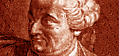
Jean Dominique’s grandson, César François Cassini, the second son of Jacques Cassini, was born in the family summer chateâu at Thury-sous-Clermont, Oise, eighty kilometres north of Paris and twenty-five kilometres east of Beauvais on the 17th June 1714. César François, also known as Cassini de Thury, followed a scientific career and has come to be referred to as Cassini III.
Siblings
César François’ older brother, Dominique Jean Cassini, was born on the 3rd July 1713, baptised the following day, and followed his father’s work in the Chambre des Comptes.
César François’ younger brother, Dominique Joseph Cassini, was born on the 27th November 1715 and pursued an extremely interesting career, beginning in the military where he became a King’s Musketeer and Marshall of the King’s camps in Flanders and, at one time, Captain of the Royal Hunt of the Prince de Condé. I have written more about him on the Babaud page.
Early years
The early life for César François was, in many ways, similar to that of his father, Jacques Dominique. Living at the Observatoire his early education was directed by his grand-uncle, Giacomo Filippo Maraldi – later known in France as Jacques Philippe Maraldi – who had been asked to come to France from his home in Perinaldo, Italy to Paris in 1687 by his uncle, Jean Dominique Cassini with a view to helping him in his work.
Jacques Phillipe Maraldi died in 1729 when César François was fifteen. César François’ education continued as he worked with his father, Jacques, with the latter gradually easing back in his researches. It is possible that Maraldi’s nephew, Giovanni Domenico Maraldi – later known as Jean Dominique Maraldi – either taught César François, or was taught along with him as he was brought from Perinaldo by Jacques Phillipe Maraldi in 1728 when Giovanni Domenico was nineteen and César François fourteen. These were formative years in the young Cassini’s life, as well as in the continuing development of the Observatoire.
Work, research and theories
César François accompanied his father on these researches in the latter’s determination to prove his hypothesis that the Earth is elongated at its poles, this in contradistinction to the Newtonian view that the Earth is flattened at its poles. This argument, which had been going on for some time, had split the Académie into two camps, Jacques and his son supporting the elongation view and Maupertuis the Newtonian view. In retrospect we now know that the argument was impossible to determine because, as Giovanni Poleni pointed out in 1733, the experimental error in the instruments used in the surveys made by the opposing camps was sufficient to make a definitive decision between the two hypotheses impossible on the data available.
César François worked with his cousin, Giovanni Domenico Maraldi, between 1732 and 1740 on establishing the boundaries of France and producing a map of 180 sheets.
The main exercises father and son carried out was to test Jacques’ hypothesis were from 1733 to 1734 when they measured the meridian from Saint Malo to Strasbourg. Nineteen at the time, César François addressed the Académie on the importance of the geodesic measurements they were making.
However, César François slowly began to change his mind and lean towards the Newtonian theory of the flattening of the Earth at its poles. His interest in cartography increasing, from 1739 to 1740 he began a survey of the meridian through Paris, establishing a large number of triangulation points and undertaking the most accurate survey of it sort to have been carried out up to that time.
César François’ data supported the view that the Earth was flattened at the poles. He published his findings in 1744 in ‘La méridienne de l'Observatoire Royal de Paris vérifiée dans toute l'étendue du royaume’.
Around this time, he was awarded the noble title of César François Cassini de Thury. It should be mentioned that César François was reported to be a Freemason, a position held by many of those in scientific society on both sides of the Channel.
Marriage
On the 24th January, 1747, César François married Charlotte-Jeanne Drouin de Vandeuil, daughter of Louis-Françoise, Président Trésorier de France. They had two children:
- Jean Dominique Cassini, and
- Françoise Elisabeth Cassini.

In 1748, just as had happened with his father, he was appointed to the Chambre des Comptes, the financial court with administrative and legal duties relating to the King's accounts, particularly the land owned by the Crown. In addition he was appointed to the office of King’s Counsel. This miniature painting by Jean-Marc Nattier, was made around 1750 and is likely to have been painted to record his settling into marriage and increasing professional eminence.
The Cassini family are recorded as living in Paris at No. 10, Rue de Babylone, in the seventh arrondissement, at the middle of the eighteenth century, and I assume that it was César François and his family that occupied that house. The reference specifically notes that he was living there in 1772 and also, curiously to me, that Mgr. Guiaud, the Papal Nuncio, was also resident at that number.
Cartography

The triangulation begun in 1740 was developed by César-François as he sought to produce the first accurate map of the whole of France. On the basis of the four hundred triangles, established on eighteen accurately measured bases, the Académie des Sciences announced the publication of his map in 1745 at a scale of 1:870,000. This was a little premature as the maps were not produced until 1746-47.
During this same period César François mapped the Netherlands and Flanders. Louis XV, seeing César François’ maps and realising their military significance, asked him to map the whole of France to the scale of 1:86,400, which was to be be accomplished on 182 sheets.
The reason for this scale was its relationship to the ‘toise’, a French unit of measurement of six ‘pieds’, or feet – about 1.949 metres – and similar in concept to the English ‘fathom’ a six-foot measure which was only used at sea, whereas the ‘toise’ was used on both land and sea. The ‘toise’ varied slightly in its length, having been amended in 1668 and 1747 and abandoned in 1812.
Louis XV agreed to the twenty year production period and an annual sum of forty thousand Livres, and César François began the process of training his team, work getting properly under way by 1750. Unfortunately, another war loomed – the Seven Years War – and Louis withdrew funding in 1755. César François approached the Académie des Sciences requesting their assistance in establishing an association to fund the work, essentially moving all mapping activities to a private company which he would own. This was successful, the King giving César François permission to produce the maps and the monopoly to sell them for a period of thirty years. The King and his mistress, Madame de Pompadour, were part of the association of fifty people funding the project, and they were joined by some of the provinces of France who wished to have their areas mapped.
Consolidation at the Paris Observatoire
In 1771 Louis XV created the post of Director of the Paris Observatoire and appointed César François to it, establishing it as a hereditary position. It is important to note that the Paris Observatoire was now no longer under the French Academy of Sciences.
In addition to being an overseas member of the Royal Society and of the Académie of Berlin, he renewed the family's links with Italy and the city of Bologna.
1775 saw the publication of his ‘Description géometrique de la terre’ and, in 1784, his ‘Description géometrique de la France.
An outbreak of smallpox in Paris took the life of César François on the 3rd or 4th September 1784 at the Observatoire, Paris 75 at the age of seventy. He was buried at the parish church of Saint-Jacques-Saint-Philippe-du-Haut-Pas, Paris. His son, Jean Dominique succeeded him to the position of Director.
The hiatus created by the change in funding effectively prolonged the mapping, it taking thirty years to complete instead of the initial estimate of twenty. At the time of César François’ death in 1784, only two of the 182 sheets had not been produced – relating to Brittany – but were completed by 1790 by his son, Jean Dominique, who had been working with his father on the mapping for the previous ten years.
Unfortunately for the Cassini family, the Convention – which was the constitutional and legislative assembly which sat from the 20th September 1792 to 26th October 1795 when its duties were taken over by the Directory, from the 2nd November 1795 until 10th November 1799 – confiscated the maps and engraving blocks on 21st September 1793, bringing them into State ownership and paying no compensation, a situation difficult for them to counter as to do so would have brought serious risk, one which saw César François’s successor, Cassini IV, decide to retire.
- The Cassini and Maraldi families
- Cassini family history
- Giovanni Domenico Cassini
- Jacques Cassini
- César François Cassini
- Jean Dominique Cassini
- Alexandre H G Cassini
- Maraldi family
- Giacomo Filippo Maraldi
- Giovanni Domenico Maraldi
- Giovanni Filippo Maraldi
- Giacomo Francisco Filippo Maraldi
- Astronomy
- Cartography
- The Babaud & Masson families
- France and England
- The Age of Enlightenment
- Joseph Cassini and Susanna Gill
- Cassini and Maraldi references